Difference between revisions of "SMT201 AY2018-19T1 EX2 Ho Xin Yi"
| Line 41: | Line 41: | ||
== Criterion Score of the four decision factors == | == Criterion Score of the four decision factors == | ||
| + | |||
=== <div style="padding: 10px; background: #DEB887; border: 1px solid #FFAA99; font-family: Trebuchet MS, sans-serif; font-size: 95%;"> <center> <big>Gombak: Criterion Score</big> </div> <br> [[File:Criterionscoreee.png|950px|frameless|center]]=== | === <div style="padding: 10px; background: #DEB887; border: 1px solid #FFAA99; font-family: Trebuchet MS, sans-serif; font-size: 95%;"> <center> <big>Gombak: Criterion Score</big> </div> <br> [[File:Criterionscoreee.png|950px|frameless|center]]=== | ||
| + | To calculate the criterion score for the four decision factors, I standardized the proximity analysis for each of the features <br><br> | ||
| + | I use the following MinMax formula: <br> | ||
| + | ["Proximity Roads@1" - Min("Proximity Roads@1")] / [Max("Proximity Roads@1") - Min("Proximity Roads@1")] <br><br> | ||
| − | === <div style="padding: 10px; background: #fff5e8; border: 1px solid #FFAA99; font-family: Trebuchet MS, sans-serif; font-size: 95%;"> <b> <big>ACCESSIBILITY FACTOR</big> <br></div>=== | + | For both the Accessibility Factor (roads) and Economic factor (Slope), I further calculate their score with [1 - MinMax] to inverse their standardized scores. This allows easy comparison between the four factors as it will be consistent throughout.<br> |
| − | + | === <div style="padding: 10px; background: #fff5e8; border: 1px solid #FFAA99; font-family: Trebuchet MS, sans-serif; font-size: 95%;"> <b> <big>ACCESSIBILITY FACTOR (ROADS)</big> <br></div>=== | |
| + | I inverse the standardized score for accessibility (roads) using [1-MinMax] as for accessibility, the closer the area is to the road, the higher the score it will be. The area represented in blue (Score 1) will be the most desirable area to build the quarantine centre if we only consider the accessibility factor. | ||
| − | === <div style="padding: 10px; background: #fff5e8; border: 1px solid #FFAA99; font-family: Trebuchet MS, sans-serif; font-size: 95%;"> <b> <big>HEALTH RISK FACTOR</big> <br></div>=== | + | === <div style="padding: 10px; background: #fff5e8; border: 1px solid #FFAA99; font-family: Trebuchet MS, sans-serif; font-size: 95%;"> <b> <big>HEALTH RISK FACTOR (BUILDINGS)</big> <br></div>=== |
| − | + | For health risk factor (buildings), the further the area is from the buildings, the higher the score. The area represented in blue (Score 1) will be the most desirable area to build the quarantine centre if we only consider the health risk factor. | |
| − | === <div style="padding: 10px; background: #fff5e8; border: 1px solid #FFAA99; font-family: Trebuchet MS, sans-serif; font-size: 95%;"> <b> <big>NATURAL CONSERVATION FACTOR</big> <br></div>=== | + | === <div style="padding: 10px; background: #fff5e8; border: 1px solid #FFAA99; font-family: Trebuchet MS, sans-serif; font-size: 95%;"> <b> <big>NATURAL CONSERVATION FACTOR (NATURAL FEATURES)</big> <br></div>=== |
| − | + | For natural conservation factor (natural features), the further the area is from the natural features, the higher the score. The area represented in blue (Score 1) will be the most desirable area to build the quarantine centre if we only consider the natural conservation factor. | |
| − | === <div style="padding: 10px; background: #fff5e8; border: 1px solid #FFAA99; font-family: Trebuchet MS, sans-serif; font-size: 95%;"> <b> <big>ECONOMIC FACTOR</big> <br></div>=== | + | === <div style="padding: 10px; background: #fff5e8; border: 1px solid #FFAA99; font-family: Trebuchet MS, sans-serif; font-size: 95%;"> <b> <big>ECONOMIC FACTOR (SLOPE)</big> <br></div>=== |
| − | + | I inverse the standardized score for economic factor (slope) using [1-MinMax] as for economic factor, the flatter the area, the higher the score it will be. The area represented in blue (Score 1) will be the most desirable area to build the quarantine centre if we only consider the economic factor. | |
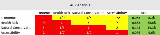
== Analytical Hierarchical Process == | == Analytical Hierarchical Process == | ||
Revision as of 00:07, 11 November 2019
Contents
Land Sustability Study For National Communicable Disease Quarantine Centre
To identify whether Gombak Subzone is suitable for building a national Communicable Disease Quarantine Centre, it must meet the four decision factors:
1) Economic factor: The selected site should avoid steep slope. This is because construction at steep slope tends to involve a lot of cut-and-fill and will lend to relatively higher development cost.
2) Accessibility factor: The selected site should be close to existing local roads, namely: service roads and tracks. This is to ensure easy transportation of building materials during the construction stage.
3) Health risk factor: The selected site should be away from population i.e. housing areas and offices in order to avoid disease spreading to the nearby population.
4) Natural conservation factor: The selected site should be away from forested land, park and water.
Overview of Gombak: Roads, Buildings, Natural Features and Digital Elevation
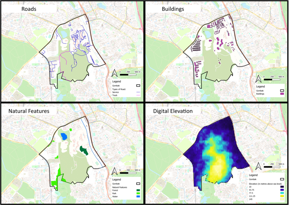

ROADS
For the overview of roads in Gombak, I only kept two types of roads, which is service and track roads. I use purple to represent the service road and pink for the track roads. As you can see, Gombak is mostly covered with service roads, with 198 service roads and only 2 track roads. They are mainly situated at the north of Gombak. At the south of Gombak, there is a large area that is not covered by both service road or track road. Hence, it might not be the best place to build the quarantine centre as it is not easily accessible.
BUILDINGS
I use purple to represent the buildings. The location of the buildings in Gombak is similar to the location of the roads. The buildings is mostly situated at the north, east and west of Gombak. At the south of Gombak, there is a large area that is not covered by any buildings. It is suitable to build the quarantine centre there as it is away from the residential area.
NATURAL FEATURES
There are three major natural features in Gombak: forest, park and water. Dark green was used to represent forest, light green was used to represent park and, blue was used to represent water. Similarly to both roads and buildings, at the south of Gombak, there is a large area without any natural features. It is suitable to build the quarantine centre there as it is away from natural features of Gombak.
DIGITAL ELEVATION
The higher the elevation of Gombak, the lighter the colour in the map gets. For Gombak, the highest elevation will be 145 metres above sea level while the lowest elevation will be 10 metres above sea level. The steeper land seems to be located at the south of Gombak.
Proximity Analysis of the four decision factors
Gombak: Proximity Analysis


PROXIMITY TO ROADS
Min = 0 metres, Max = 453 metres
The suggested proximity to roads (accessibility factor) will be less than 200 metres away from the road. Any other distance will be less desirable as it is hard to access the location to transport goods during the construction of the quarantine centre. In the map, blue is used to represent areas which is more than 200 metres away from the roads which is not what we desired. For the rest of the colour, it shows area within the 200 metres from the roads, as the colours get darker, the closer the area is to the road.
PROXIMITY TO BUILDINGS
Min = 0 metres, Max = 557 metres
The suggested proximity to buildings (health risk factor) will be 250 metres away from the population. Any distance nearer might pose as a health risk to the residents in Gombak. In the map, the desired distance of 250 metres and more is represented with blue while the rest of the colour will be less than 250 metres away from the buildings. Within the 250 metres, as the colour gets darker, the nearer the location is to the buildings. Hence, the higher the health risks is for the residents.
PROXIMITY TO NATURAL FEATURES
Min = 0 metres, Max = 518 metres
Similar to buildings, the suggested proximity to natural features (natural conservation factors) will be 250 metres away from the natural features. In the map, the desired distance of 250 metres and more is represented with blue while the rest of the colour will be less than 250 metres away from the natural features. Within the 250 metres, as the colour gets darker, the nearer the location is to the natural features.
SLOPE
Min = 0 degree, Max = 35.6279 degree
The suggested degree of slope will be less than 15 degree. In the map, the undesirable slope of more than 15 degree is represented in blue while the rest of the colours will have a slope of less than 15 degree. The darker the colour, the flatter the area is.
Criterion Score of the four decision factors
Gombak: Criterion Score
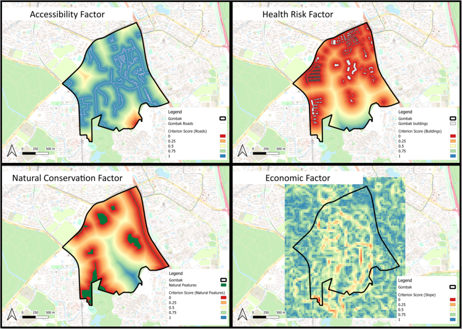

To calculate the criterion score for the four decision factors, I standardized the proximity analysis for each of the features
I use the following MinMax formula:
["Proximity Roads@1" - Min("Proximity Roads@1")] / [Max("Proximity Roads@1") - Min("Proximity Roads@1")]
For both the Accessibility Factor (roads) and Economic factor (Slope), I further calculate their score with [1 - MinMax] to inverse their standardized scores. This allows easy comparison between the four factors as it will be consistent throughout.
ACCESSIBILITY FACTOR (ROADS)
I inverse the standardized score for accessibility (roads) using [1-MinMax] as for accessibility, the closer the area is to the road, the higher the score it will be. The area represented in blue (Score 1) will be the most desirable area to build the quarantine centre if we only consider the accessibility factor.
HEALTH RISK FACTOR (BUILDINGS)
For health risk factor (buildings), the further the area is from the buildings, the higher the score. The area represented in blue (Score 1) will be the most desirable area to build the quarantine centre if we only consider the health risk factor.
NATURAL CONSERVATION FACTOR (NATURAL FEATURES)
For natural conservation factor (natural features), the further the area is from the natural features, the higher the score. The area represented in blue (Score 1) will be the most desirable area to build the quarantine centre if we only consider the natural conservation factor.
ECONOMIC FACTOR (SLOPE)
I inverse the standardized score for economic factor (slope) using [1-MinMax] as for economic factor, the flatter the area, the higher the score it will be. The area represented in blue (Score 1) will be the most desirable area to build the quarantine centre if we only consider the economic factor.
Analytical Hierarchical Process
AHP report for decision factors: Accessibility, Health Risk, Natural Conservation, and Economic

xxxxxxxxxxxxxxxxx
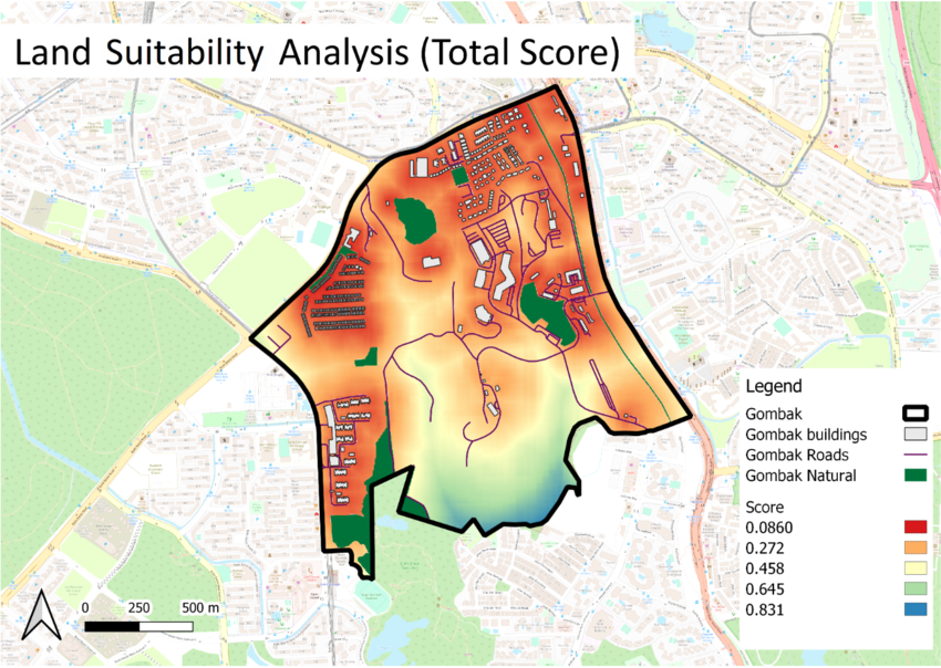
Land Suitability Analysis
Gombak Land Suitability
xxxxxxxxxxxxxxxxx
Combined Criterion Score

xxxxxxxxxxxxxxxxx
Percentage


xxxxxxxxxxxxxxxxxx


