Difference between revisions of "SMT201 AY2019-20G2 Ex1 FOO CHUAN GENG"
Jump to navigation
Jump to search
Cgfoo.2018 (talk | contribs) |
Cgfoo.2018 (talk | contribs) |
||
| Line 2: | Line 2: | ||
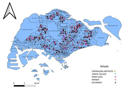
* Distribution of public education institution | * Distribution of public education institution | ||
| − | + | [[File:All Schools .jpg|none|500px|caption]] | |
| − | + | Hello ... | |
| − | |||
* Hierarchy of road network system | * Hierarchy of road network system | ||
| Line 11: | Line 10: | ||
* 2014 Master Plan Landuse | * 2014 Master Plan Landuse | ||
| − | * [[File:MASTERPLAN 2014 LANDUSE.png| | + | * [[File:MASTERPLAN 2014 LANDUSE.png|none|500px|caption]] |
| − | I categorize the map based on the Land Usage , initially i wanted to group the attributes with common words , but i feel that those attributes may meant different operations to the planner | + | I categorize the map based on the Land Usage , initially i wanted to group the attributes with common words , but i feel that those attributes may meant different operations to the planner ... |
| − | e.g. Buisness 1 , Buisness 1 - White, Business 2 | + | e.g. Buisness 1 , Buisness 1 - White, Business 2 ... |
== Part 2: Choropleth Mapping == | == Part 2: Choropleth Mapping == | ||
Revision as of 23:20, 16 September 2019
Part 1: Thematic Mapping
- Distribution of public education institution

Hello ...
- Hierarchy of road network system

- 2014 Master Plan Landuse

I categorize the map based on the Land Usage , initially i wanted to group the attributes with common words , but i feel that those attributes may meant different operations to the planner ... e.g. Buisness 1 , Buisness 1 - White, Business 2 ...
Part 2: Choropleth Mapping
- Aged population (+65) in 2010 and 2018.


- Proportional of aged population in 2010 and 2018.


- Percentage change of aged population between 2010 and 2018.
