Difference between revisions of "SMT201 AY2019-20T1 EX1 Sabrina Liau Ying Ying"
Jump to navigation
Jump to search
| Line 2: | Line 2: | ||
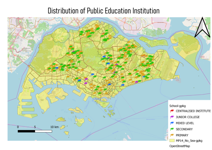
=== Public Education Institution Distribution in Singapore === | === Public Education Institution Distribution in Singapore === | ||
| − | + | [[File:School map sab liau 19.png|700px|frameless|center]] | |
=== Singapore's Road Section Line === | === Singapore's Road Section Line === | ||
| − | + | [[File:RoadSection Map|700px|frameless|center|]] | |
=== 2014 Master Plan Landuse === | === 2014 Master Plan Landuse === | ||
=== File Structure for | === File Structure for | ||
| − | + | [[|thumb|[[File:MP14_Land.png|700px|center|2014 Master Plan Landuse]]]] | |
Part One === | Part One === | ||
| Line 16: | Line 16: | ||
=== Age Population (65+) in Singapore by Subzone for Year 2010 & 2018 === | === Age Population (65+) in Singapore by Subzone for Year 2010 & 2018 === | ||
| − | |||
=== Proportion of Aged Population (65+) in Singapore by Subzone for Year 2010 & 2018 === | === Proportion of Aged Population (65+) in Singapore by Subzone for Year 2010 & 2018 === | ||
=== Percentage Change of Aged Population (65+) in Singapore by Subzone from the Year 2010 to 2018 === | === Percentage Change of Aged Population (65+) in Singapore by Subzone from the Year 2010 to 2018 === | ||
Revision as of 20:59, 15 September 2019
Contents
Part One
Public Education Institution Distribution in Singapore

Singapore's Road Section Line
2014 Master Plan Landuse
=== File Structure for
[[|thumb|
]]
Part One ===