Difference between revisions of "SMT201 AY2019-20T1 EX1 Kok Su Yee"
Jump to navigation
Jump to search
| Line 14: | Line 14: | ||
=== Road Network Systems in Singapore === | === Road Network Systems in Singapore === | ||
| − | [[File:Road Network Systems in Singapore.png|700px|center]] | + | <!--[[File:Road Network Systems in Singapore.png|700px|center]] --> |
=== 2014 Master Plan Land Use in Singapore === | === 2014 Master Plan Land Use in Singapore === | ||
| + | <!--[[File:2014 Master Plan Land Use Map.png|700px|center]] --> | ||
| − | + | ==<span style="background: #E5EBFC; padding: 8px;>Part 2: Choropleth Mapping</span>== | |
=== Aged population (Above 65) in 2010 === | === Aged population (Above 65) in 2010 === | ||
| − | <!-- [[File: | + | <!--[[File:Aged population (Above 65) in 2010 .png|700px|center]] --> |
=== Aged population (Above 65) in 2018 === | === Aged population (Above 65) in 2018 === | ||
| − | <!-- [[File: | + | <!--[[File:Aged Population (Above 65) in 2018.png|700px|center]] --> |
=== Proportion of Aged population in 2010 === | === Proportion of Aged population in 2010 === | ||
| − | |||
| + | <!--[[File:Proportion of Aged Population (2010).png|700px|center]] --> | ||
=== Proportion of Aged population in 2018 === | === Proportion of Aged population in 2018 === | ||
| − | <!-- [[File: | + | <!--[[File:Proportion of Aged Population (2018).png|700px|center]] --> |
=== Percentage change of Aged Population between 2010 and 2018 === | === Percentage change of Aged Population between 2010 and 2018 === | ||
| − | <!-- [[File: | + | <!--[[File:Percentage Change of Aged Population (2010 and 2018).png|700px|center]] --> |
=== Reasoning for classification choices, deriving new variables and handling of missing values === | === Reasoning for classification choices, deriving new variables and handling of missing values === | ||
Revision as of 14:07, 15 September 2019
Contents
- 1 Take Home Exercise 1: Mapping the Urban World
- 2 Part 1: Thematic Mapping
- 3 Part 2: Choropleth Mapping
- 3.1 Aged population (Above 65) in 2010
- 3.2 Aged population (Above 65) in 2018
- 3.3 Proportion of Aged population in 2010
- 3.4 Proportion of Aged population in 2018
- 3.5 Percentage change of Aged Population between 2010 and 2018
- 3.6 Reasoning for classification choices, deriving new variables and handling of missing values
- 4 References
Take Home Exercise 1: Mapping the Urban World
Part 1: Thematic Mapping
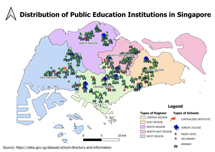
Distribution of Public Education Institutions in Singapore

Road Network Systems in Singapore
2014 Master Plan Land Use in Singapore
Part 2: Choropleth Mapping
Aged population (Above 65) in 2010
Aged population (Above 65) in 2018
Proportion of Aged population in 2010
Proportion of Aged population in 2018
Percentage change of Aged Population between 2010 and 2018
Reasoning for classification choices, deriving new variables and handling of missing values
References
Singapore Resident Population Data [1]
2014 Master Plan Land Use Data [2]
2014 Master Plan Region Data [3]
2014 Master Planning Area Data [4]
Road Section Line Data [5]
Types of Schools in Singapore Data [6]
Understand Road Categories "Road Line Plan Explanatory Notes"
Understand Properties in Singapore [7]