Difference between revisions of "SMT201 AY2019-20G1 EX2 Nigel Poon Wei Chun"
| Line 6: | Line 6: | ||
Using the selected infrastructures, we hope to find a suitable area to build the next National Communicable Disease Quarantine Centre within Gombak. We will have various factors in mind while deciding the location such as Economic, Accessibility, Health Risk and Natural Conservation which will be talked further in detail later. | Using the selected infrastructures, we hope to find a suitable area to build the next National Communicable Disease Quarantine Centre within Gombak. We will have various factors in mind while deciding the location such as Economic, Accessibility, Health Risk and Natural Conservation which will be talked further in detail later. | ||
| − | + | ||
| + | |||
| + | |||
| + | With the above layouts, we can have a rough understanding of locations of buildings, natural features as well as service and track roads which will be our target roads of this insight report. The bottom right map layout show the elevation of Gombak with the redder values being higher elevation | ||
| − | == | + | == Part 2 == |
| − | === | + | === Proximity to Natural Features, Buildings , Target Roads and Slope === |
| + | [[File:NIGEL_Layout_2.png|800px|center]] | ||
==== 2010 ==== | ==== 2010 ==== | ||
Revision as of 23:33, 10 November 2019
Part 1
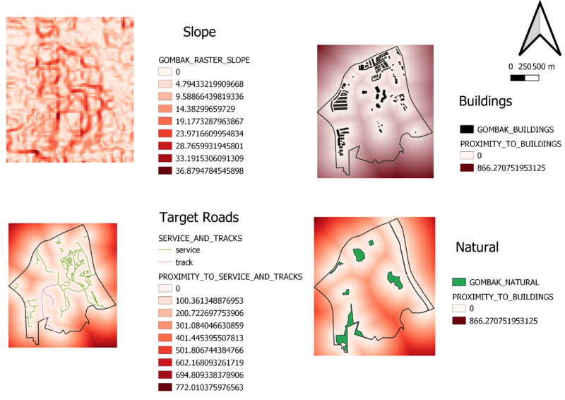
Study area (Gombak) with it's elevation and its infrastructure ( Target roads, Buildings , Natural Features )
Using the selected infrastructures, we hope to find a suitable area to build the next National Communicable Disease Quarantine Centre within Gombak. We will have various factors in mind while deciding the location such as Economic, Accessibility, Health Risk and Natural Conservation which will be talked further in detail later.
With the above layouts, we can have a rough understanding of locations of buildings, natural features as well as service and track roads which will be our target roads of this insight report. The bottom right map layout show the elevation of Gombak with the redder values being higher elevation
Part 2
Proximity to Natural Features, Buildings , Target Roads and Slope
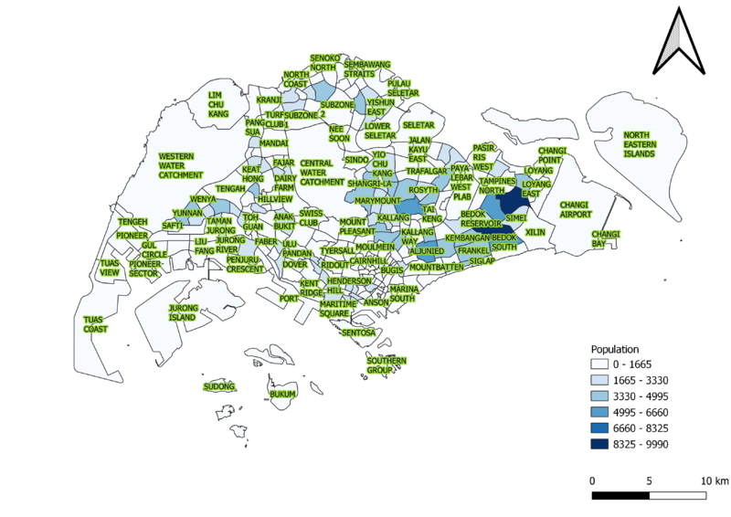
2010
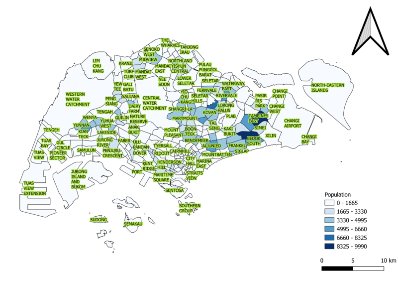
2018
The maps were connected differently 2018 data to 2014 masterplan shapefile, 2010 data to 2008 shapefile. This is to ensure that the data would correspond accurately to the polygons
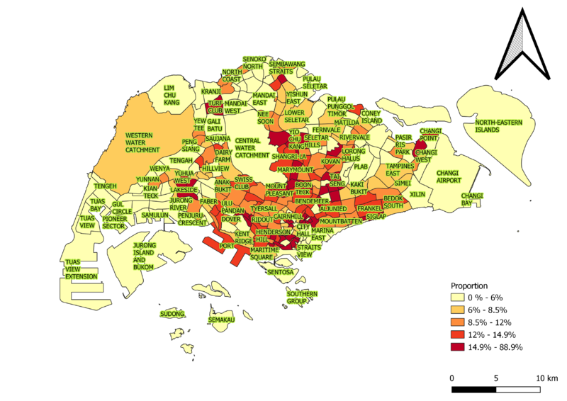
Major of the elderly live in the Tampines, Bedok, Serangoon, Toa payoh and Thomson as well as the neighbourhood around these highlighted areas.
In the bigger picture through the years. the elderly population as slightly increased and this very apparent in Kian Teck
Proportion Aged 65+
2010
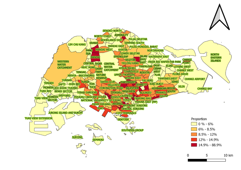
2018
The maps were connected differently 2018 data to 2014 masterplan shapefile, 2010 data to 2008 shapefile. This is to ensure that the data would correspond accurately to the polygons
A large number of subzones are becoming matured estates.
This trend is very visible in the subzones near Yio Chu Kang and Clementi proximity
Percentage Change between 2010 and 2018
Both 2010 and 2018 data were connected to the 2014 masterplan shapefile to show differences. With an extra background layer which accounts for missing data or new subzones which have been drafted
As a whole Singapore is having a large amount of its subzone becoming matured estates with little replacement of younger residents .
Sembawang East is currently facing the fastest change of its population.

