Difference between revisions of "G1-Group07 Proposal"
| (30 intermediate revisions by the same user not shown) | |||
| Line 1: | Line 1: | ||
{| style="background-color:#3d2b63 ;margin:0px 0px 0px 0px;width="100%" | | {| style="background-color:#3d2b63 ;margin:0px 0px 0px 0px;width="100%" | | ||
| − | | style="font-family:Courier; font-size:15px; text-align: center; border-top:solid # | + | | style="font-family:Courier; font-size:15px; text-align: center; border-top:solid #3d2b63; border-bottom:solid #3d2b63" width="250px" | |
| − | [[G1-Group07|<font color="# | + | [[G1-Group07|<font color="#eb7fe9"><strong>HOME</strong></font>]] |
| − | | style="font-family:Courier; font-size:15px; text-align: center; border-top:solid # | + | | style="font-family:Courier; font-size:15px; text-align: center; border-top:solid #3d2b63; border-bottom:solid #3d2b63" width="250px" | |
| − | [[G1-Group07_Proposal|<font color="# | + | [[G1-Group07_Proposal|<font color="#eb7fe9"><strong>PROPOSAL</strong></font>]] |
| − | | style="font-family:Courier; font-size:15px; text-align: center; border-top:solid # | + | | style="font-family:Courier; font-size:15px; text-align: center; border-top:solid #3d2b63; border-bottom:solid #3d2b63" width="250px" | |
| − | [[G1-Group07_Poster|<font color="# | + | [[G1-Group07_Poster|<font color="#eb7fe9"><strong>POSTER</strong></font>]] |
| − | | style="font-family:Courier; font-size:15px; text-align: center; border-top:solid #eb7fe9; border-bottom:solid # | + | | style="font-family:Courier; font-size:15px; text-align: center; border-top:solid #3d2b63; border-bottom:solid #3d2b63" width="200px" | |
| − | [[G1-Group07_Final_Report|<font color="# | + | [[G1-Group07_Web_Maps|<font color="#eb7fe9"><strong>WEB MAPS</strong></font>]] |
| + | |||
| + | | style="font-family:Courier; font-size:15px; text-align: center; border-top:solid #3d2b63; border-bottom:solid #3d2b63" width="250px" | | ||
| + | [[G1-Group07_Final_Report|<font color="#eb7fe9"><strong>FINAL REPORT</strong></font>]] | ||
|} | |} | ||
| Line 28: | Line 31: | ||
We first chose to focus on one planning area, Jurong East, to carry out this analysis. The methodology can be scaled up and used on other planning areas in the future to improve the land use of Singapore as a whole. | We first chose to focus on one planning area, Jurong East, to carry out this analysis. The methodology can be scaled up and used on other planning areas in the future to improve the land use of Singapore as a whole. | ||
| + | |||
The following smart-city features were used for our analysis: | The following smart-city features were used for our analysis: | ||
| − | |||
| − | 2) Transportation | + | 1) Housing |
| + | |||
| + | 2) Transportation | ||
| + | |||
| + | 3) Education | ||
| + | |||
| + | 4) Economy | ||
| + | |||
| + | 5) Healthcare | ||
| + | |||
| + | 6) Environment | ||
| + | |||
| + | 7) Public Spaces | ||
| + | |||
| + | 8) Other amenities and facilities (eg shopping centres) | ||
| − | |||
| − | |||
| − | |||
| − | |||
| − | |||
| − | |||
These 3 population demographics were narrowed down for our analysis: | These 3 population demographics were narrowed down for our analysis: | ||
| − | 1) Young (aged 0-14) | + | |
| − | 2) Economically active (aged 25 to 64) | + | 1) Young (aged 0-14) |
| − | 3) Seniors (aged 65 and above) | + | |
| + | 2) Economically active (aged 25 to 64) | ||
| + | |||
| + | 3) Seniors (aged 65 and above) | ||
=<div style="margin-top: 10px;font-family: Courier;font-weight:bold;text-align:center;font-size:20px; border: 5px solid #00000000; border-radius:8px;text-align:center; background-color: #eb7fe9; color: black; padding: 2px"><span style="font-size:24px;"></span>About Jurong East</div>= | =<div style="margin-top: 10px;font-family: Courier;font-weight:bold;text-align:center;font-size:20px; border: 5px solid #00000000; border-radius:8px;text-align:center; background-color: #eb7fe9; color: black; padding: 2px"><span style="font-size:24px;"></span>About Jurong East</div>= | ||
| + | |||
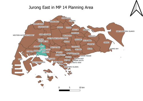
| + | [[File:Project Proposal Jurong East in MP 14 Planning Area.png|500px|center|Jurong East in MP 14 Planning Area]] | ||
| + | |||
| + | Jurong East, located in the west region of Singapore with an area of 17 km^2, is a planning area and residential town with an estimated of 80,000 residents (2019). Today, Jurong East is a new town bustling with lots of new housing and commercial developments, attracting many to live and work with good transportation network mainly served by Jurong East MRT, Chinese Garden MRT and Jurong East Bus Interchange. There are many amenities for various purposes and there are several tourist attractions have also made Jurong East more bustling. Jurong East is home to Singapore’s first business park, International Business Park, which is managed by JTC and is home to many international and homegrown companies. Jurong Port which is in Jurong East is also said to have played a key role in Singapore’s economic growth. | ||
| + | |||
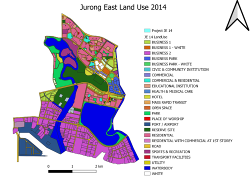
| + | Below shows the Jurong East Planning Area that is clipped out from 2014 Master Plan's land use planning area. The smaller areas of Jurong East are categorized according to their different land uses (please refer to legend on diagram). | ||
| + | |||
| + | [[File:Project Proposal Jurong East Land Use 2014.png|500px|center|Jurong East Land Use 2014]] | ||
=<div style="margin-top: 10px;font-family: Courier;font-weight:bold;text-align:center;font-size:20px; border: 5px solid #00000000; border-radius:8px;text-align:center; background-color: #eb7fe9; color: black; padding: 2px"><span style="font-size:24px;"></span>Data Sources</div>= | =<div style="margin-top: 10px;font-family: Courier;font-weight:bold;text-align:center;font-size:20px; border: 5px solid #00000000; border-radius:8px;text-align:center; background-color: #eb7fe9; color: black; padding: 2px"><span style="font-size:24px;"></span>Data Sources</div>= | ||
| Line 55: | Line 77: | ||
|- | |- | ||
|-style= "background-color:#E98074" | |-style= "background-color:#E98074" | ||
| − | !scope="row" colspan="4"|<b>''Landuse (2008/2014/2019 | + | !scope="row" colspan="4"|<b>''Landuse (2008/2014)''</b> |
| + | |- | ||
| + | | MP08 Land Use || SHP ||https://data.gov.sg/dataset/mp08-land-use | ||
| + | |- | ||
| + | | Master Plan 2008 Planning Area || SHP ||https://data.gov.sg/dataset/master-plan-2008-planning-area-boundary-no-sea | ||
| + | |- | ||
| + | | Master Plan 2008 Planning Area || SHP ||https://data.gov.sg/dataset/master-plan-2008-planning-area-boundary-no-sea | ||
| + | |- | ||
| + | | Master Plan 2008 Subzone || SHP ||https://data.gov.sg/dataset/master-plan-2008-subzone-boundary-no-sea | ||
| + | |- | ||
| + | | Master Plan 2014 Land Use || SHP ||https://data.gov.sg/dataset/master-plan-2014-land-use | ||
| + | |- | ||
| + | | Master Plan 2014 Planning Area || SHP ||https://data.gov.sg/dataset/master-plan-2014-planning-area-boundary-no-sea | ||
| + | |- | ||
| + | | Master Plan 2014 Subzone || SHP ||https://data.gov.sg/dataset/master-plan-2014-subzone-boundary-no-sea | ||
| + | |- | ||
| + | | Buildings || SHP ||https://download.bbbike.org/osm/bbbike/Singapore/ | ||
| + | |- | ||
| + | | HDB Property Information || CSV ||https://data.gov.sg/dataset/hdb-property-information | ||
| + | |- | ||
| + | | ASTER Global Digital Elevation Model (GDEM) || TIF ||https://search.earthdata.nasa.gov/search?m=-7.175!25.59375!1!1!0!0%2C2 | ||
| + | |- | ||
| + | !scope="row" colspan="4"|<b>''Population Data''</b> | ||
| + | |- | ||
| + | | Singapore Residents by Planning Area Subzone, Age Group, Sex and Type of Dwelling, June 2000-2019 || CSV ||https://www.singstat.gov.sg/find-data/search-by-theme/population/geographic-distribution/latest-data | ||
| + | |- | ||
| + | !scope="row" colspan="4"|<b>''Transport Data''</b> | ||
| + | |- | ||
| + | | Bus Stop Location || SHP||https://www.mytransport.sg/content/mytransport/home/dataMall/search_datasets.html?searchText=bus%20stop | ||
| + | |- | ||
| + | | Train Station || SHP||https://www.mytransport.sg/content/mytransport/home/dataMall/search_datasets.html?searchText=train | ||
| + | |- | ||
| + | | Roads || SHP||https://download.bbbike.org/osm/bbbike/Singapore/ | ||
| + | |- | ||
| + | | Cycling Path Network || SHP||https://data.gov.sg/dataset/cycling-path-network | ||
| + | |- | ||
| + | | Park Connector Line || SHP||https://data.gov.sg/dataset/sdcp-park-connector-line | ||
| + | |- | ||
| + | !scope="row" colspan="4"|<b>''Amenities Data''</b> | ||
| + | |- | ||
| + | | Eldercare Services || SHP||https://data.gov.sg/dataset/eldercare-services?resource_id=81244fb2-9d1b-4bd8-98ff-49c041fe53ac | ||
| + | |- | ||
| + | | CHAS Clinics || KML||https://data.gov.sg/dataset/chas-clinics | ||
| + | |- | ||
| + | | Silver Zone || SHP||https://www.mytransport.sg/content/mytransport/home/dataMall/static-data.html | ||
|- | |- | ||
| + | | Traffic || SHP||https://www.mytransport.sg/content/mytransport/home/dataMall/static-data.html | ||
| + | |- | ||
| + | | Hawker Centres || KML||https://data.gov.sg/dataset/hawker-centres | ||
| + | |- | ||
| + | | Fast Food || CSV||https://data.gov.sg/dataset/list-of-nea-licensed-eating-establishments-with-grades-demerit-points-and-suspension-history | ||
| + | |- | ||
| + | | Parks || SHP||https://data.gov.sg/dataset/parks | ||
| + | |- | ||
| + | | Childcare Services || Text||https://skoolopedia.com/app/childcare/area/jurong-east | ||
| + | |- | ||
| + | | Pre-Schools || Text||https://www.google.com.sg/search?q=pre+schools+in+jurong+east&ie=&oe= | ||
| + | |- | ||
| + | | Schools || CSV||https://data.gov.sg/dataset/school-directory-and-information | ||
|} | |} | ||
| − | |||
=<div style="margin-top: 10px;font-family: Courier;font-weight:bold;text-align:center;font-size:20px; border: 5px solid #00000000; border-radius:8px;text-align:center; background-color: #eb7fe9; color: black; padding: 2px"><span style="font-size:24px;"></span>Project Timeline</div>= | =<div style="margin-top: 10px;font-family: Courier;font-weight:bold;text-align:center;font-size:20px; border: 5px solid #00000000; border-radius:8px;text-align:center; background-color: #eb7fe9; color: black; padding: 2px"><span style="font-size:24px;"></span>Project Timeline</div>= | ||
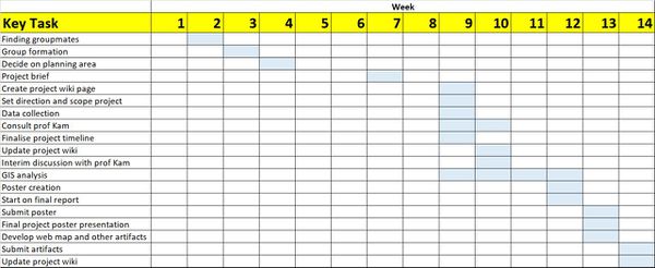
| + | [[File:Gantt Chart.jpg|600px|center]] | ||
=<div style="margin-top: 10px;font-family: Courier;font-weight:bold;text-align:center;font-size:20px; border: 5px solid #00000000; border-radius:8px;text-align:center; background-color: #eb7fe9; color: black; padding: 2px"><span style="font-size:24px;"></span>Scope of Work</div>= | =<div style="margin-top: 10px;font-family: Courier;font-weight:bold;text-align:center;font-size:20px; border: 5px solid #00000000; border-radius:8px;text-align:center; background-color: #eb7fe9; color: black; padding: 2px"><span style="font-size:24px;"></span>Scope of Work</div>= | ||
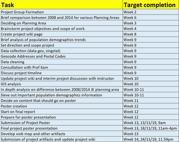
| + | [[File:Scope of Work.jpg|600px|center]] | ||
=<div style="margin-top: 10px;font-family: Courier;font-weight:bold;text-align:center;font-size:20px; border: 5px solid #00000000; border-radius:8px;text-align:center; background-color: #eb7fe9; color: black; padding: 2px"><span style="font-size:24px;"></span>Project Reference</div>= | =<div style="margin-top: 10px;font-family: Courier;font-weight:bold;text-align:center;font-size:20px; border: 5px solid #00000000; border-radius:8px;text-align:center; background-color: #eb7fe9; color: black; padding: 2px"><span style="font-size:24px;"></span>Project Reference</div>= | ||
Latest revision as of 19:32, 24 October 2020
Contents
Proposal
Project Motivation
Singapore, the world’s third most densely populated place with 7148 people per km^2, is a city state with scarce land area of 721.5km^2 and population of 5.8 million people in 2019. With this limited land space, Singapore has to fit all its infrastructural needs such as housing, schools, transport network, parks etc to meet the needs of its people and reach social objectives while preventing overcrowding and balancing the demands for growth with maintaining Singapore’s status as a ‘Garden City’. Urban planning is also important in creating the ground for collaboration between local governments, private sector and public to take ownership of the quality of life in Singapore.
With the importance of urban planning in mind, we are motivated to use Geographic Information Systems to ensure improved urban planning for one of the planning areas in Singapore, Jurong East, by utilizing already collected data such as land use, population demographics and educational facilities as well as primary data.
Project Objectives
Our objective is to identify any gaps that could be closed and effectively recommend changes or new uses of the land in Jurong East to meet the needs of residents, workers and visitors of Jurong East. This is done by using QGIS to integrate various kinds of data together and observe how they interact with one another that could have a huge impact on the quality of life in that particular area.
We first chose to focus on one planning area, Jurong East, to carry out this analysis. The methodology can be scaled up and used on other planning areas in the future to improve the land use of Singapore as a whole.
The following smart-city features were used for our analysis:
1) Housing
2) Transportation
3) Education
4) Economy
5) Healthcare
6) Environment
7) Public Spaces
8) Other amenities and facilities (eg shopping centres)
These 3 population demographics were narrowed down for our analysis:
1) Young (aged 0-14)
2) Economically active (aged 25 to 64)
3) Seniors (aged 65 and above)
About Jurong East
Jurong East, located in the west region of Singapore with an area of 17 km^2, is a planning area and residential town with an estimated of 80,000 residents (2019). Today, Jurong East is a new town bustling with lots of new housing and commercial developments, attracting many to live and work with good transportation network mainly served by Jurong East MRT, Chinese Garden MRT and Jurong East Bus Interchange. There are many amenities for various purposes and there are several tourist attractions have also made Jurong East more bustling. Jurong East is home to Singapore’s first business park, International Business Park, which is managed by JTC and is home to many international and homegrown companies. Jurong Port which is in Jurong East is also said to have played a key role in Singapore’s economic growth.
Below shows the Jurong East Planning Area that is clipped out from 2014 Master Plan's land use planning area. The smaller areas of Jurong East are categorized according to their different land uses (please refer to legend on diagram).


