Difference between revisions of "G2-Group08 Proposal"
| (30 intermediate revisions by 2 users not shown) | |||
| Line 37: | Line 37: | ||
|- | |- | ||
| | | | ||
| − | As part of our module, Geographic Information Systems for Urban Planning, we are collaborating with an international food chain to analyse 15 trade areas located in Taiwan's Kaohsiung and Ping Tung region. The international food chain currently uses manual methods of delineating their trade area which is largely time consuming. Therefore we aim to propose new and faster methods using QGIS to delineate the trade area. <br> | + | |
| + | [[File:Kaohsiung Stores.jpg|400px|frameless|left]] | ||
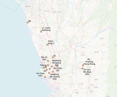
| + | As part of our module, Geographic Information Systems for Urban Planning, we are collaborating with an international food chain to analyse 15 trade areas located in Taiwan's Kaohsiung and Ping Tung region as shown in the image below. The international food chain currently uses manual methods of delineating their trade area which is largely time consuming. Therefore we aim to propose new and faster methods using QGIS to delineate the trade area. <br> | ||
| Line 45: | Line 47: | ||
<!-- END OF PROJECT MOTIVATION ---> | <!-- END OF PROJECT MOTIVATION ---> | ||
| + | |||
| + | <div style="background: #EDCDC0; padding: 20px; line-height: 0em; text-indent: 0px;letter-spacing:0.0em;font-size:18px; text-align: left"><font color=#ffffff face="Roboto">'''About Kaohsiung and Ping Tung'''</font></div> | ||
| + | {| class="wikitable" style="background-color:#FFFFFF;" width="100%" | ||
| + | |- | ||
| + | | | ||
| + | Kaohsiung is a port city located in Southern Taiwan. It has a population of 2,770,000 people. Sitting between Cijin Island and downtown, Port of Kaohsiung is a world-class port in Taiwan as well as a hub for international trade. The ceaseless ships and containers from around the world represent the energy and vitality of the business in Kaohsiung. | ||
| + | |||
| + | Ping Tung county is a county also located in Southern Taiwan. It is the fifth-largest county in Taiwan. It is well known for its top attractions such as Kenting National Park and Ngoluanpi Park. Ping Tung also has some of Taiwan's best natural attractions such as amazing beaches, mountains and farmlands. | ||
| + | |||
| + | |- | ||
| + | |} | ||
<!-- Body --> | <!-- Body --> | ||
| Line 59: | Line 72: | ||
2. To analyse and generate insights into the current trade areas with respect to the selected points of interest and sales revenue | 2. To analyse and generate insights into the current trade areas with respect to the selected points of interest and sales revenue | ||
| − | |||
| − | |||
| − | |||
| − | |||
| − | |||
|} | |} | ||
| Line 74: | Line 82: | ||
<div style="background: #EDCDC0; padding: 20px; line-height: 0em; text-indent: 0px;letter-spacing:0.0em;font-size:18px; text-align: left"><font color=#ffffff face="Roboto">'''Data'''</font></div> | <div style="background: #EDCDC0; padding: 20px; line-height: 0em; text-indent: 0px;letter-spacing:0.0em;font-size:18px; text-align: left"><font color=#ffffff face="Roboto">'''Data'''</font></div> | ||
| + | ===Geospatial Data=== | ||
{| style="background-color:#ffffff;" width="100%" | {| style="background-color:#ffffff;" width="100%" | ||
|- | |- | ||
| Line 81: | Line 90: | ||
!style= "background-color: #EDCDC0"| Name !!style= "background-color: #EDCDC0"| Description !!style= "background-color: #EDCDC0"| Geographic Representation !!style= "background-color: #EDCDC0"| Data Format !!style= "background-color: #EDCDC0"| Source !!style= "background-color: #EDCDC0"| Used in | !style= "background-color: #EDCDC0"| Name !!style= "background-color: #EDCDC0"| Description !!style= "background-color: #EDCDC0"| Geographic Representation !!style= "background-color: #EDCDC0"| Data Format !!style= "background-color: #EDCDC0"| Source !!style= "background-color: #EDCDC0"| Used in | ||
|- | |- | ||
| − | | Taiwan Stores || Contains store locations allocated to each group || Point || | + | | Taiwan Stores || Contains store locations allocated to each group || Point || Geopackage || Professor Kam, Client || Allocation of Stores, Trade area delineation methods |
|- | |- | ||
|-style= "background-color:#EDCDC0" | |-style= "background-color:#EDCDC0" | ||
| Line 118: | Line 127: | ||
|- | |- | ||
| TravDest|| Travel Destinations in South Taiwan || Point || ESRI Shapefile || Client || Sales Revenue Analysis | | TravDest|| Travel Destinations in South Taiwan || Point || ESRI Shapefile || Client || Sales Revenue Analysis | ||
| + | |- | ||
| + | |-style= "background-color:#EDCDC0" | ||
| + | !scope="row" colspan="6"|<b>''Store Sales''</b> | ||
| + | |- | ||
| + | | Store Sales Data || Revenue from sales by POD Code || NIL || CSV || Client || Sales Revenue Analysis | ||
|} | |} | ||
|- | |- | ||
| Line 123: | Line 137: | ||
===Location Maps=== | ===Location Maps=== | ||
| + | ''The location maps were used as a reference when digitising the operational trade area.'' | ||
| + | |||
{| class="wikitable" | {| class="wikitable" | ||
|- | |- | ||
!style= "background-color: #EDCDC0"| Name !!style= "background-color: #EDCDC0"| Description !!style= "background-color: #EDCDC0"| Data Format !!style= "background-color: #EDCDC0"| Source !!style= "background-color: #EDCDC0"| Used in | !style= "background-color: #EDCDC0"| Name !!style= "background-color: #EDCDC0"| Description !!style= "background-color: #EDCDC0"| Data Format !!style= "background-color: #EDCDC0"| Source !!style= "background-color: #EDCDC0"| Used in | ||
|- | |- | ||
| − | | CK-20190624寬109cm長130 || Location Map for trade area | + | | CK-20190624寬109cm長130 || Location Map for trade area Shih Chuan, Kaohsiung County || Powerpoint || Client || Trade area Digitisation |
| + | |- | ||
| + | | JK-20190314寬83高72(木)含框 || Location Map for trade area Jiangong, Sanmin District, Kaohsiung City || Powerpoint || Client || Trade area Digitisation | ||
|- | |- | ||
| − | | | + | | KS20190823(外送範圍) || Location Map for Kang Shan Town, Kaohsiung County 820 || Powerpoint || Client || Trade area Digitisation |
|- | |- | ||
| − | | | + | | LJ-20171030寬89高120(木)含框 || Location Map for Lujhu District, Kaohsiung City || Powerpoint || Client || Trade area Digitisation |
|- | |- | ||
| − | | | + | | NZ地圖.jpg || Location Map for Nan Zi, Kaohsiung || Powerpoint || Client || Trade area Digitisation |
|- | |- | ||
| − | | | + | | NJ-20150902寬100高90(木) || Location Map for Nanzih District, Kaohsiung City || Powerpoint || Client || Trade area Digitisation |
|- | |- | ||
| − | | | + | | PM-20171124寬84高76(鋁) || Location Map for Ming Shan Road, Pintong || Powerpoint || Client || Trade area Digitisation |
|- | |- | ||
| − | | | + | | PZ-20171215寬82高76(鋁) || Location Map for Ping Tung Zhong Zheng || Powerpoint || Client || Trade area Digitisation |
|- | |- | ||
| − | | QD-20180913寬80高100(木) || Location Map for | + | | QD-20180913寬80高100(木) || Location Map for Qie Ding District, Kaohsiung City || Powerpoint || Client || Trade area Digitisation |
|- | |- | ||
| − | | RM-20190107寬110高110(木)含框 || Location Map for | + | | RM-20190107寬110高110(木)含框 || Location Map for Renwu District, Kaohsiung City || Powerpoint || Client || Trade area Digitisation |
|- | |- | ||
| − | | RZ-20190314寬90高119.7(木)含框 || Location Map for | + | | RZ-20190314寬90高119.7(木)含框 || Location Map for Zuoying District, Kaohsiung City || Powerpoint || Client || Trade area Digitisation |
|- | |- | ||
| − | | TS-20190624-鋁-寬65高80 || Location Map for | + | | TS-20190624-鋁-寬65高80 || Location Map for Tso Ying Delco, Kaohsiung || Powerpoint || Client || Trade area Digitisation |
|- | |- | ||
| − | | UC-20171226寬70高90(鋁) || Location Map for | + | | UC-20171226寬70高90(鋁) || Location Map for Yen Cheng District, Kaohsiung City || Powerpoint || Client || Trade area Digitisation |
|- | |- | ||
| − | | ZH-20190527寬90高88.8(鋁)含框 || Location Map for | + | | ZH-20190527寬90高88.8(鋁)含框 || Location Map for Gushan District, Kaohsiung City || Powerpoint || Client || Trade area Digitisation |
|- | |- | ||
| − | | ZY || Location Map for | + | | ZY || Location Map for Tsoying Zi Yo, Kaohsiung || Powerpoint || Client || Trade area Digitisation |
|} | |} | ||
| Line 169: | Line 187: | ||
| | | | ||
1. Digitising the existing Trade Area<br> | 1. Digitising the existing Trade Area<br> | ||
| + | We would need to digitise the existing hand-drawn trade area by referring to the location maps given | ||
2. Extracting Points of Interest<br> | 2. Extracting Points of Interest<br> | ||
| + | We would need to extract the points of interest from the shapefiles given. | ||
3. Trade Area Delineation method (Buffer)<br> | 3. Trade Area Delineation method (Buffer)<br> | ||
| + | We would need to delineate 2.5km, 3km and 3.5km buffers and analyse whether it would be a suitable replacement method. | ||
4. Trade Area Delineation method (Drive Time)<br> | 4. Trade Area Delineation method (Drive Time)<br> | ||
| + | We would need to delineate 15 minutes drive time boundary using QGIS' QNEAT function. | ||
| + | |||
| + | 5. Sales revenue analysis<br> | ||
| + | We would need to analyse the sales revenue namely bills, total revenue and average bills to find the correlation between sales and points of interest or other factors such as population. | ||
| − | + | [[File:Timeline G2G8.png|700px|frameless|center]] | |
|- | |- | ||
|} | |} | ||
| Line 187: | Line 212: | ||
<!-- End Body ---> | <!-- End Body ---> | ||
<br> | <br> | ||
| − | <div style="background: #EDCDC0; padding: 20px; line-height: 0em; text-indent: 0px;letter-spacing:0.0em;font-size:18px; text-align: left"><font color=#ffffff face="Roboto">''' | + | <div style="background: #EDCDC0; padding: 20px; line-height: 0em; text-indent: 0px;letter-spacing:0.0em;font-size:18px; text-align: left"><font color=#ffffff face="Roboto">'''References'''</font></div> |
| − | |||
| − | |||
{| style="background-color:#FFFFFF;" width="100%" | {| style="background-color:#FFFFFF;" width="100%" | ||
|- | |- | ||
| | | | ||
| − | [[ | + | [https://www.kcg.gov.tw/EN/cp.aspx?n=E5AA72D4F35F91D0 Kaohsiung City Government]<br> |
| + | |||
| + | [https://en.wikipedia.org/wiki/Pingtung_County Ping Tung County] | ||
| + | |||
| + | [https://www.lonelyplanet.com/taiwan/pingtung-county Pingtung County Travel] | ||
| + | |||
| + | [https://www.taiwannews.com.tw/en/news/3416395 Seven must-see attractions in Pingtung] | ||
|- | |- | ||
|} | |} | ||
<!-- END OF PROJECT SCHEDULE ---> | <!-- END OF PROJECT SCHEDULE ---> | ||
Latest revision as of 23:59, 24 November 2019
|
As part of our module, Geographic Information Systems for Urban Planning, we are collaborating with an international food chain to analyse 15 trade areas located in Taiwan's Kaohsiung and Ping Tung region as shown in the image below. The international food chain currently uses manual methods of delineating their trade area which is largely time consuming. Therefore we aim to propose new and faster methods using QGIS to delineate the trade area.
|
|
Kaohsiung is a port city located in Southern Taiwan. It has a population of 2,770,000 people. Sitting between Cijin Island and downtown, Port of Kaohsiung is a world-class port in Taiwan as well as a hub for international trade. The ceaseless ships and containers from around the world represent the energy and vitality of the business in Kaohsiung. Ping Tung county is a county also located in Southern Taiwan. It is the fifth-largest county in Taiwan. It is well known for its top attractions such as Kenting National Park and Ngoluanpi Park. Ping Tung also has some of Taiwan's best natural attractions such as amazing beaches, mountains and farmlands. |
|
There are two main objectives of this project: |
Geospatial Data
| ||||||||||||||||||||||||||||||||||||||||||||||||||||||||||||||||||||||||||||||||||||||||||||||||||||||||||||||||||||||||||||||
Location Maps
The location maps were used as a reference when digitising the operational trade area.
| Name | Description | Data Format | Source | Used in |
|---|---|---|---|---|
| CK-20190624寬109cm長130 | Location Map for trade area Shih Chuan, Kaohsiung County | Powerpoint | Client | Trade area Digitisation |
| JK-20190314寬83高72(木)含框 | Location Map for trade area Jiangong, Sanmin District, Kaohsiung City | Powerpoint | Client | Trade area Digitisation |
| KS20190823(外送範圍) | Location Map for Kang Shan Town, Kaohsiung County 820 | Powerpoint | Client | Trade area Digitisation |
| LJ-20171030寬89高120(木)含框 | Location Map for Lujhu District, Kaohsiung City | Powerpoint | Client | Trade area Digitisation |
| NZ地圖.jpg | Location Map for Nan Zi, Kaohsiung | Powerpoint | Client | Trade area Digitisation |
| NJ-20150902寬100高90(木) | Location Map for Nanzih District, Kaohsiung City | Powerpoint | Client | Trade area Digitisation |
| PM-20171124寬84高76(鋁) | Location Map for Ming Shan Road, Pintong | Powerpoint | Client | Trade area Digitisation |
| PZ-20171215寬82高76(鋁) | Location Map for Ping Tung Zhong Zheng | Powerpoint | Client | Trade area Digitisation |
| QD-20180913寬80高100(木) | Location Map for Qie Ding District, Kaohsiung City | Powerpoint | Client | Trade area Digitisation |
| RM-20190107寬110高110(木)含框 | Location Map for Renwu District, Kaohsiung City | Powerpoint | Client | Trade area Digitisation |
| RZ-20190314寬90高119.7(木)含框 | Location Map for Zuoying District, Kaohsiung City | Powerpoint | Client | Trade area Digitisation |
| TS-20190624-鋁-寬65高80 | Location Map for Tso Ying Delco, Kaohsiung | Powerpoint | Client | Trade area Digitisation |
| UC-20171226寬70高90(鋁) | Location Map for Yen Cheng District, Kaohsiung City | Powerpoint | Client | Trade area Digitisation |
| ZH-20190527寬90高88.8(鋁)含框 | Location Map for Gushan District, Kaohsiung City | Powerpoint | Client | Trade area Digitisation |
| ZY | Location Map for Tsoying Zi Yo, Kaohsiung | Powerpoint | Client | Trade area Digitisation |
|
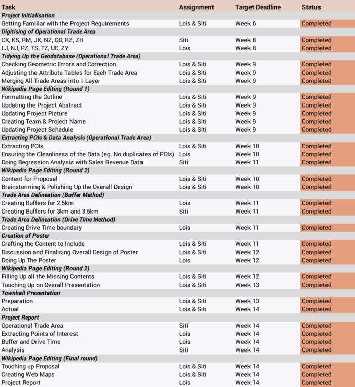
1. Digitising the existing Trade Area 2. Extracting Points of Interest 3. Trade Area Delineation method (Buffer) 4. Trade Area Delineation method (Drive Time) 5. Sales revenue analysis |


