Difference between revisions of "SMT201 AY2019-20G2 EX2 Ong Krystal"
| (One intermediate revision by the same user not shown) | |||
| Line 73: | Line 73: | ||
== Suitability Land Lots == | == Suitability Land Lots == | ||
| − | + | Map with Overall Score | |
[[File:Map5a_KrystalOng.jpg|border|center|800x800px|]] | [[File:Map5a_KrystalOng.jpg|border|center|800x800px|]] | ||
From the map showing the scores, I further did a reclassification. Areas that had a score of > 0.6 would be reclassed to 1 while a score of <= 0.6 would be reclassed to 0. Areas with a reclassed value of 1 would mean it is suitable to build a quarantine centre in that area. The map below shows the reclassed map based on the land suitability. | From the map showing the scores, I further did a reclassification. Areas that had a score of > 0.6 would be reclassed to 1 while a score of <= 0.6 would be reclassed to 0. Areas with a reclassed value of 1 would mean it is suitable to build a quarantine centre in that area. The map below shows the reclassed map based on the land suitability. | ||
| − | + | Reclassed Map | |
[[File:Map5b_KrystalOng.jpg|border|center|800x800px|]] | [[File:Map5b_KrystalOng.jpg|border|center|800x800px|]] | ||
After I reclassed the Gombak Subzone, I polygonize the raster layer to convert it to a vector layer. Once the layer is vector, I added a column to determine the area of the suitable land lot (which is represented by the areas with a reclassed value of 1). However, since the quarantine centre should have a contiguous area of at least 10,000m2, a suitable area should have an area larger than 10,000m2. | After I reclassed the Gombak Subzone, I polygonize the raster layer to convert it to a vector layer. Once the layer is vector, I added a column to determine the area of the suitable land lot (which is represented by the areas with a reclassed value of 1). However, since the quarantine centre should have a contiguous area of at least 10,000m2, a suitable area should have an area larger than 10,000m2. | ||
| − | + | Identification of Suitable Land Area | |
[[File:Map5c_KrystalOng.jpg|border|center|800x800px|]] | [[File:Map5c_KrystalOng.jpg|border|center|800x800px|]] | ||
| − | + | Details of Suitable Land Area | |
[[File:Map5d_KrystalOng.JPG|border|center|800x800px|]] | [[File:Map5d_KrystalOng.JPG|border|center|800x800px|]] | ||
As such, the area highlighted in green, with an area of 34,520m2, is suitable for building a national Communicable DIsease Quarantine Centre. | As such, the area highlighted in green, with an area of 34,520m2, is suitable for building a national Communicable DIsease Quarantine Centre. | ||
Latest revision as of 21:21, 10 November 2019
Contents
Task
To identify a location suitable for building a national Communicable Disease Quarantine Centre. The selected site must be located at Gombak planning subzone, with a contiguous area of at least 10,000m2 and it must meet the following decision factors:
Economic factor: The selected site should avoid steep slope. This is because construction at steep slope tends to involve a lot of cut-and-fill and will lend to relatively higher development cost.
Accessibility factor: The selected site should be close to existing local roads, namely: service roads and tracks. This is to ensure easy transportation of building materials during the construction stage.
Health risk factor: The selected site should be away from population i.e. housing areas and offices in order to avoid disease spreading to the nearby population.
Natural conservation factor: The selected site should be away from forested land, park and water.
Study Area
Roads: Since the chosen area should be close to existing road, specifically service roads and tracks, I categorised the roads into the 2 following roads, where the service road is in green while tracks are in red. There is more service road present in the North-East of Gombak Subzone while there is only 1 track located from central to South-West Gombak.
Buildings: From the Health Risk Factor, the selected site should be away from population like housing areas and offices. From my map, I realised that there were more buildings present in the top half of Gombak Subzone and in the South West region. As such, the site can be located away from these areas.
Natural Features: As the selected site should be away from Natural Features like forested land, park and water, I classified the natural features into these 3 categories. Forested land is represented by the green area, park as the blue area and water as the red area. There are not many natural features in Gombak, with only 1 forested land, 3 water areas and 4 parks.
Elevation: The selected site should be away from steep slopes. From my map, the lowest area in Gombak is 8m above sea level, which is shown in blue. The highest is 143m above sea level, shown in red and is mainly located in the south region of Gombak.
Proximity Analysis
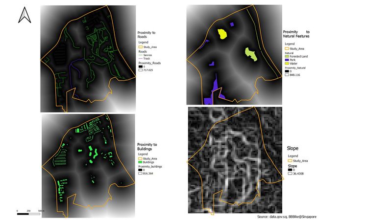
Proximity to Roads: Areas that are darker in colour would mean that it is nearer from roads. Since the quarantine centre wants to be closer to existing local roads, area that is darker in colour would be more suitable in terms of accessibility.
Proximity to Buildings: Areas that are lighter would mean the area is further from population. Since the quarantine centre wants to be further from population, area that is lighter would fulfil the requirements in terms of the health risk factor.
Proximity to Nature: Areas with a lighter colour would mean the area is further from natural features. Since the quarantine centre wants to be away from forested land, park and water, areas that are lighter will be more suitable for the centre.
Slope: The centre wants to be built away from a steep slope. Areas with a darker colour would mean that the area has a lower elevation, in terms of degrees. This would mean that the darker the area on the map, the more suitable it is to build the centre.
Criterion Scores
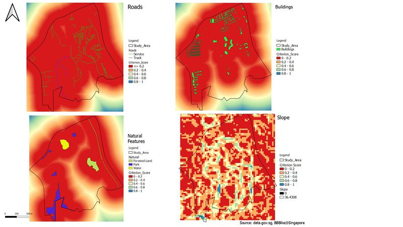
I made use of the min-max standardisation formula: (X – Xmin)/ (Xmax – Xmin) to come up with the criterion score for each of the individual maps. The scores for all maps should range from 0 to 1. From there, I further split into intervals of 0.2, where each interval is represented by a colour. By using the standardisation formula, it ensures that all maps are on the same unit and scale.
Accessibility (Roads): Since the quarantine centre should be near roads, we should look out for areas where there is a lower criterion score. A lower criterion score would mean that the area is further from roads due to the high proximity to roads. In the Gombak subzone, the central area of Gombak, which is denoted by red colour, has a lower criterion score, suggesting it is the furthest from the roads.
Health Risk (Buildings): The quarantine centre wants to be further away from buildings. A higher criterion score would then mean the area has a low proximity to buildings and hence, is further away from it. As such, a higher criterion score would achieve the objective of the quarantine centre better.
Natural Conservation (Natural Features): Similarly, we should look out for areas with a high criterion score. This is because the quarantine centre wants to be away from natural features. With a higher criterion score, this would mean that the area is closer to the natural features, meeting the objective of the quarantine centre.
Economic (Slope): We should look out for areas with a lower criterion score in this map as the selected site has to avoid steep slope. Similar to accessibility, a lower criterion score suggests that the area is further from areas that have a high degree of elevation. As a result, a lower criterion score will mean that the quarantine section meets its target of avoiding areas with a steep slope.
Analytical Hierarchical Process (AHP) Input Matrix and Results Report
This report was generated using the template provided by SCBUK. From my pairwise comparison matrix, I ranked health risk, accessibility, natural conservation and economic, in decreasing importance. However, I ranked health risk and accessibility of close importance, as seen from the closeness in values from the matrix.
I felt that health risk was the most important factor as the quarantine centre would contain many patients carrying highly infectious disease. Being close to houses and offices would definitely cause the spread of such disease and could possibly cause a disease outbreak. Accessibility is also very important as more materials being transported to the area so that the centre can be built more quickly. This is necessary to prevent the disease from spreading to other healthy citizens. Natural conservation is of third importance as natural areas like water bodies could potentially spread bacteria from the disease centre. Economic factor is of the least importance as the government would most likely provide financial support when it comes to building health centres for the citizens.
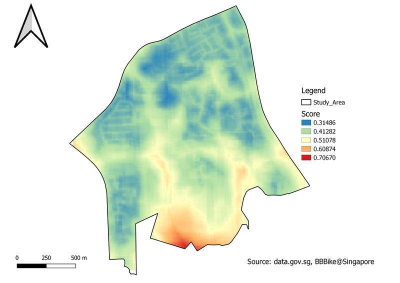
First, I calculated the total score of the different areas in Gombak using this formula: (0.322*(1- "Normalised_roads@1") )+ (0.051*(1 - "Normalised_slope@1"))+ (0.112*("Normalised_natural@1")) + (0.515*("Normalised_buildings@1")).
As a result, I obtained the map with the total score to determine which area was more suitable to build the quarantine centre. The higher the score, the more suitable it would be to build the centre.
Suitability Land Lots
Map with Overall Score
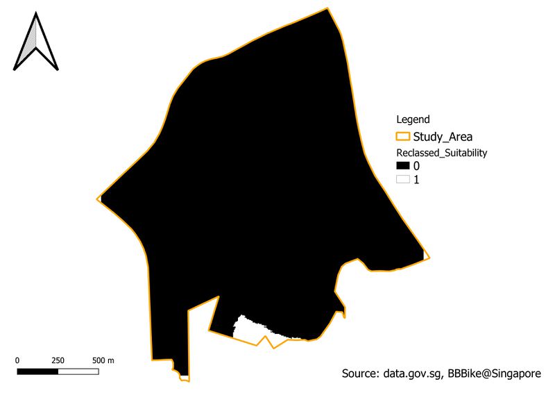
From the map showing the scores, I further did a reclassification. Areas that had a score of > 0.6 would be reclassed to 1 while a score of <= 0.6 would be reclassed to 0. Areas with a reclassed value of 1 would mean it is suitable to build a quarantine centre in that area. The map below shows the reclassed map based on the land suitability.
Reclassed Map
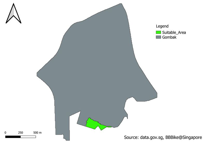
After I reclassed the Gombak Subzone, I polygonize the raster layer to convert it to a vector layer. Once the layer is vector, I added a column to determine the area of the suitable land lot (which is represented by the areas with a reclassed value of 1). However, since the quarantine centre should have a contiguous area of at least 10,000m2, a suitable area should have an area larger than 10,000m2.
Identification of Suitable Land Area
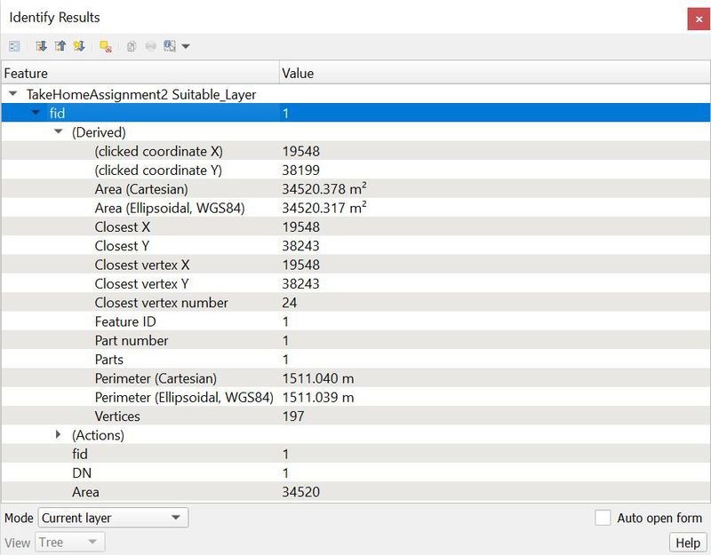
Details of Suitable Land Area
As such, the area highlighted in green, with an area of 34,520m2, is suitable for building a national Communicable DIsease Quarantine Centre.
