Difference between revisions of "SMT201 AY2019-20G2 EX2 Tu Yang Lin"
| Line 48: | Line 48: | ||
From the four views above, the area that are dark turquoise are the suitable areas for the building of CDQC. The road map where areas are dark turquoise, implies that it is close to the road. Similarly, areas on the slope map with the same colour implies that it is less steep. For the building and natural features map that are with the same colour (dark turquoise) implies that the area are far buildings and natural features. | From the four views above, the area that are dark turquoise are the suitable areas for the building of CDQC. The road map where areas are dark turquoise, implies that it is close to the road. Similarly, areas on the slope map with the same colour implies that it is less steep. For the building and natural features map that are with the same colour (dark turquoise) implies that the area are far buildings and natural features. | ||
| + | <br> | ||
| + | == ''Analytical Hierarchical Process (AHP)'' == | ||
Revision as of 19:02, 10 November 2019
Contents
Overview of Study Area (Gombak)
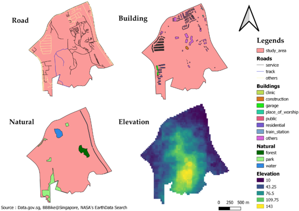
Gombak Overview Map Layout
Roads
The accessibility factor for building the national Communicable Disease Quarantine Centre (CDQC) is for the selected site to be close to existing local roads (service roads and tracks), which will ensure easy transportation of building materials during the construction stage.
Within our study area, there are a total of 199 service roads and 2 tracks. As shown from the map above, I choose to use black and blue to represent the service roads and tracks respectively, while the other roads are yellow in colour.
Buildings
The health risk factor for building CDQC is for the selected site to be away from population, such as housing areas and offices, in order to avoid disease spreading to the nearby population. There is a total of 527 buildings in Gombak. While majority of the buildings are categorised, there are some that are not classified into any of the categories. As such, I have categorised them under “others”. As seen from the map above, the area at the south of Gombak does not have any buildings which could be taken into consideration for building the CDQC.
Natural
The natural conservation factor for building CDQC is for the selected site to be away from forested land, park and water. The location of the natural features is similar to where the buildings are located, which means that the same south area of Gombak can be considered.
Slope
The economic factor for building CDQC is for the selected site to avoid steep slope, as it tends to involve a lot of cut-and-fill and will lead to relatively higher development cost during the construction stage. The elevation for Gombak ranges from 10m to 143m (above sea level). As seen from the map, the yellow area (south of Gombak) was supposed to be the ideal site for constructing the CDQC after considering the natural conversation and health risk factor. However, its high elevation made it undesirable for building of CDQC. This also explains why there were no buildings built at this area.
Study Area and Proximity to Target
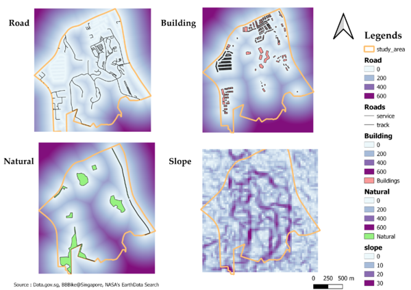
Proximity Map Layout
Other than the slope layer, I have adjusted the proximity range from 0 metres to 600 meters with an interval of 200 meters each. This will allow better visualisation and comparison to be made.
Proximity to Road
As shown from the map, the areas within Gombak are accessible within 200 metres of the road. This is desirable during the construction stage as transportation would be more convenient with the road close to the area.
Proximity to Buildings
As seen from the map, there is an area at the South of Gombak that is about 400 metres away from the buildings. While the other areas are only about 0 metres to 200 metres away which should not be considered as a suitable site for building CQDC as it may cause disease to spread.
Proximity to Natural Features
From the map, the same area at the South of Gombak is at least 200 metres away from the natural features which can be considered as the selected site.
Proximity to Slope
From the map, it can be seen that the area around the centre to the South of Gombak has a pretty steep slope (about 30 degree). As such, the selected site should be around these area as the steep slope will affect the development cost and also the construction process.
Criterion Scores
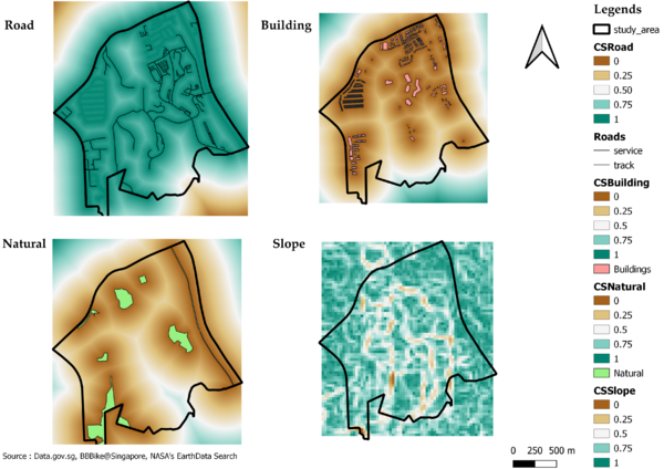
Criterion Scores Map Layout
As I notice that the factors are in metres, expect for slope which is in degree. In order to standardise the scale of the various factor layers, I used the Min-Max method.
Min-Max Formula
Description
After standardising the scale, I inverse the road and slope by using (1 - normalised roads) and (1 - normalised slope) respectively. As a smaller value for road and slope and a bigger value for building and natural feature will fulfill the criteria.
From the four views above, the area that are dark turquoise are the suitable areas for the building of CDQC. The road map where areas are dark turquoise, implies that it is close to the road. Similarly, areas on the slope map with the same colour implies that it is less steep. For the building and natural features map that are with the same colour (dark turquoise) implies that the area are far buildings and natural features.


