Difference between revisions of "SMT201 AY2018-19T1 EX2 Ho Xin Yi"
(Created page with "== Land Sustability Study For National Communicable Disease Quarantine Centre == To identify a location suitable for building a national Communicable Disease Quarantine Centre...") |
|||
| Line 1: | Line 1: | ||
== Land Sustability Study For National Communicable Disease Quarantine Centre == | == Land Sustability Study For National Communicable Disease Quarantine Centre == | ||
| − | To identify | + | |
| + | To identify whether Gombak Subzone is suitable for building a national Communicable Disease Quarantine Centre, it must meet the four decision factors: <br> | ||
1) Economic factor: The selected site should avoid steep slope. This is because construction at steep slope tends to involve a lot of cut-and-fill and will lend to relatively higher development cost. <br> | 1) Economic factor: The selected site should avoid steep slope. This is because construction at steep slope tends to involve a lot of cut-and-fill and will lend to relatively higher development cost. <br> | ||
2) Accessibility factor: The selected site should be close to existing local roads, namely: service roads and tracks. This is to ensure easy transportation of building materials during the construction stage. <br> | 2) Accessibility factor: The selected site should be close to existing local roads, namely: service roads and tracks. This is to ensure easy transportation of building materials during the construction stage. <br> | ||
3) Health risk factor: The selected site should be away from population i.e. housing areas and offices in order to avoid disease spreading to the nearby population. <br> | 3) Health risk factor: The selected site should be away from population i.e. housing areas and offices in order to avoid disease spreading to the nearby population. <br> | ||
| − | 4) Natural conservation factor: The selected site should be away from forested land, park and water. | + | 4) Natural conservation factor: The selected site should be away from forested land, park and water. <br><br> |
| − | |||
| − | |||
| − | |||
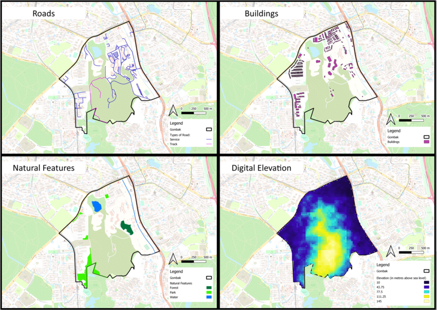
| + | === <div style="padding: 10px; background: #DEB887; border: 1px solid #FFAA99; font-family: Trebuchet MS, sans-serif; font-size: 95%;"> <center> Overview of Gombak: Roads, Buildings, Natural Features and Digital Elevation </div> <br> [[File:4 Factors of Gombak.png|850px|frameless|center]] === | ||
| − | |||
| − | === | + | === <div style="padding: 10px; background: #fff5e8; border: 1px solid #FFAA99; font-family: Trebuchet MS, sans-serif; font-size: 95%;"> <b> <big>ROADS</big> <br></div>=== |
| + | xxxxxxxxxxxxxxxxxxxxxxx | ||
| + | === <div style="padding: 10px; background: #fff5e8; border: 1px solid #FFAA99; font-family: Trebuchet MS, sans-serif; font-size: 95%;"> <b> <big>BUILDINGS</big> <br></div>=== | ||
| + | === <div style="padding: 10px; background: #fff5e8; border: 1px solid #FFAA99; font-family: Trebuchet MS, sans-serif; font-size: 95%;"> <b> <big>NATURAL FEATURES</big> <br></div>=== | ||
| + | === <div style="padding: 10px; background: #fff5e8; border: 1px solid #FFAA99; font-family: Trebuchet MS, sans-serif; font-size: 95%;"> <b> <big>DIGITAL ELEVATION</big> <br></div>=== | ||
| − | |||
| − | |||
| − | == | + | == Proximity Analysis of the four decision factors == |
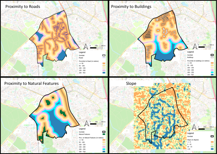
| − | + | === <div style="padding: 10px; background: #DEB887; border: 1px solid #FFAA99; font-family: Trebuchet MS, sans-serif; font-size: 95%;"> Gombak: Proximity Analysis of Roads, Buildings, Natural Features and Digital Elevation </div> <br> [[File:Proximity analysis.png|850px|frameless|center]] === | |
| − | |||
| − | + | xxxxxx | |
| − | |||
Revision as of 18:23, 10 November 2019
Contents
Land Sustability Study For National Communicable Disease Quarantine Centre
To identify whether Gombak Subzone is suitable for building a national Communicable Disease Quarantine Centre, it must meet the four decision factors:
1) Economic factor: The selected site should avoid steep slope. This is because construction at steep slope tends to involve a lot of cut-and-fill and will lend to relatively higher development cost.
2) Accessibility factor: The selected site should be close to existing local roads, namely: service roads and tracks. This is to ensure easy transportation of building materials during the construction stage.
3) Health risk factor: The selected site should be away from population i.e. housing areas and offices in order to avoid disease spreading to the nearby population.
4) Natural conservation factor: The selected site should be away from forested land, park and water.
Overview of Gombak: Roads, Buildings, Natural Features and Digital Elevation
ROADS
xxxxxxxxxxxxxxxxxxxxxxx
BUILDINGS
NATURAL FEATURES
DIGITAL ELEVATION
Proximity Analysis of the four decision factors
Gombak: Proximity Analysis of Roads, Buildings, Natural Features and Digital Elevation
xxxxxx

