Difference between revisions of "SMT201 AY2019-20G2 Ex1 Ng Poh Yeng"
Jump to navigation
Jump to search
| Line 2: | Line 2: | ||
=== Level of Schools === | === Level of Schools === | ||
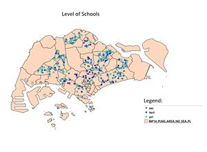
| − | + | The legend of the map clearly shows the different school categories - primary, secondary and tertiary. Mixed school does not have a category on its own because it is being added into either secondary or tertiary category. The colour chosen for the labels are 3 different shades of blue. Starting from the light shade of blue to represent the primary school, followed by the medium shade of blue to represent the secondary school and lastly the darkest shade of blue to represent the tertiary school. There are overlapping points due to the closeness of the school as some are side by side each other, therefore overlap of labels are unavoidable. | |
[[File:Schoolmap.png|thumb]] | [[File:Schoolmap.png|thumb]] | ||
| − | |||
=== Road Network System === | === Road Network System === | ||
Revision as of 01:21, 15 September 2019
Contents
Part One: Thematic Mapping
Level of Schools
The legend of the map clearly shows the different school categories - primary, secondary and tertiary. Mixed school does not have a category on its own because it is being added into either secondary or tertiary category. The colour chosen for the labels are 3 different shades of blue. Starting from the light shade of blue to represent the primary school, followed by the medium shade of blue to represent the secondary school and lastly the darkest shade of blue to represent the tertiary school. There are overlapping points due to the closeness of the school as some are side by side each other, therefore overlap of labels are unavoidable.
Road Network System
nnn
2014 Master Plan Landuse
nnn
