Difference between revisions of "SMT201 AY2019-20G1 EX2 Kok Jim Meng"
| Line 153: | Line 153: | ||
Thereafter, we shall add in target roads, buildings, and nature features into the subzone. Furthermore, we will look into the elevation as well. | Thereafter, we shall add in target roads, buildings, and nature features into the subzone. Furthermore, we will look into the elevation as well. | ||
[[File:Jim WWC Subzone Land Use roads buildings natural.png|800px|center]] | [[File:Jim WWC Subzone Land Use roads buildings natural.png|800px|center]] | ||
| + | [[File:Jim WWCSubzoneLandUse DEM.png|800px|center]] | ||
| + | From the two maps above, we can see that Western Water Catchment is a flat land subzone. Furthermore, there is high in accessibility and natural conservation factors and low in health risk factor in the north region and southwest region. | ||
| + | <p> | ||
| + | After standardizing the proximities, here is the composite map layout of the four factors. According to the criterion scores, blue colour represents the most suitable while red colour represents the least suitable in building the quarantine centre in the Western Water Catchment subzone. However, it seems that Western Water Catchment is in favor of accessibility and economic factor. Further analysis has to be done. As such, I will use the same AHP mentioned in this Take Home Exercise earlier. | ||
==References== | ==References== | ||
[https://data.gov.sg/dataset/master-plan-2014-subzone-boundary-no-sea 2014 Master Plan Subzone]<br> | [https://data.gov.sg/dataset/master-plan-2014-subzone-boundary-no-sea 2014 Master Plan Subzone]<br> | ||
Revision as of 16:30, 10 November 2019
Contents
Part 1: Map Layouts of Extractions
Target Roads
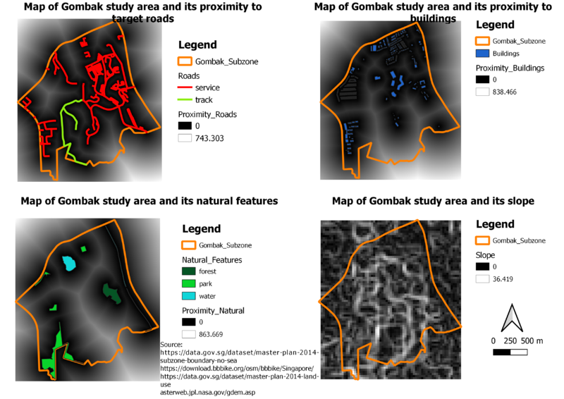
There is a higher number of target road networks in the central and eastern part of the Gombak study area. To build the quarantine centre, it is suitable to build at these areas due to the transportation of the materials for the construction of the quarantine centre.
Buildings
By using Master Plan 2014 Land Use and OSM’s buildings layer, I intersect them and classify them according to the building types. Residential buildings are saturated in the western side and northern side of the study area. Furthermore, military buildings (i.e. Bukit Panjang Camp) are at the central of the study area. In addition, train stations are at the eastern side of the study area. Hence, it is ideal to set up the quarantine centre at the southern side of the study area to stay away from those stated buildings.
Target Natural Features
According to the three types of nature features namely forest, parks, and water, the proposed quarantine centre needs to stay away from these nature features. Hence, it is ideal to set up the quarantine centre at the southern side of the study area.
Digital Elevation
The colours of the elevation are represented where green means flat land, orange-yellow means mid-level land, and red means high-level land. To fulfill the economic factor of building at gentle slope, it is suitable to build the quarantine centre at the green areas of the slope according to the raster.
Part 2: Map Layouts of Proximity
Proximity to Target Roads
The darker the values, the more suitable for the proposed quarantine centre to be constructed. Hence, this allows the accessibility of the transportation of the materials to construct the quarantine centre. With 5 metres by 5 metres resolution, the nearest road within the study area of Gombak is 0 metres. The furthest distance from the buildings is 743.303 metres.
Proximity to Buildings
The lighter the values, the more suitable for the proposed quarantine centre to be constructed. Hence, this is to ensure the quarantine centre to be built is staying away from the buildings. With 5 metres by 5 metres resolution, the nearest road within the study area of Gombak is 0 metres. The furthest distance from the roads is 838.466 metres.
Proximity to Target Natural Features
The lighter the values, the more suitable for the proposed quarantine centre to be constructed. Hence, this is to ensure the quarantine centre to be built is staying away from the nature features. With 5 metres by 5 metres resolution, the nearest road within the study area of Gombak is 0 metres. The furthest distance from the roads is 863.669 metres.
Slope
As mentioned earlier in first part of this Take Home Exercise, slopes are based on the elevation. The darker the values, the flatter the land is. Hence, the darker values are considered suitable for the quarantine centre to be constructed. With 30 metres by 30 metres resolution, the maximum steepness is approximately 36.419 degrees. As shown in the map, most areas of the study area are flat.

