Difference between revisions of "SMT201 AY2019-20G2 EX2 Tu Yang Lin"
Jump to navigation
Jump to search
| Line 4: | Line 4: | ||
'' Overview '' | '' Overview '' | ||
[[File:Layout overview.png|600px|frameless|center]] | [[File:Layout overview.png|600px|frameless|center]] | ||
| + | <br> | ||
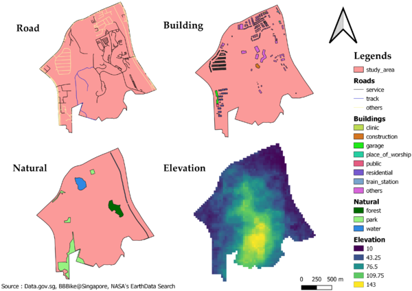
| + | === Roads === | ||
| + | The accessibility factor for building the national Communicable Disease Quarantine Centre (CDQC) is for the selected site to be close to existing local roads (service roads and tracks), which will ensure easy transportation of building materials during the construction stage. | ||
| + | Within our study area, there are a total of 199 service roads and 2 tracks. As shown from the map above, I choose to use black and blue to represent the service roads and tracks respectively, while the other roads are yellow in colour. | ||
Revision as of 16:13, 10 November 2019
Overview of Study Area (Gombak)
Overview

Roads
The accessibility factor for building the national Communicable Disease Quarantine Centre (CDQC) is for the selected site to be close to existing local roads (service roads and tracks), which will ensure easy transportation of building materials during the construction stage. Within our study area, there are a total of 199 service roads and 2 tracks. As shown from the map above, I choose to use black and blue to represent the service roads and tracks respectively, while the other roads are yellow in colour.