Difference between revisions of "SMT201 AY2019-20G2 Ex2 Ng Poh Yeng"
| (2 intermediate revisions by the same user not shown) | |||
| Line 35: | Line 35: | ||
AHP matrix is chosen as it has inbuilt checks and balances to ensure that you reach logically consistent solutions when you compare the relative importance the criteria in the process of assigning weights to them. | AHP matrix is chosen as it has inbuilt checks and balances to ensure that you reach logically consistent solutions when you compare the relative importance the criteria in the process of assigning weights to them. | ||
In the case of Gombak, I believe that the government and citizens will place a lot of emphasis on the health risk factor as Gombak is a dense subzone which might cause a widespread of a disease once there is a leakage of bacteria. | In the case of Gombak, I believe that the government and citizens will place a lot of emphasis on the health risk factor as Gombak is a dense subzone which might cause a widespread of a disease once there is a leakage of bacteria. | ||
| − | I believe that accessibility and Nature factor holds a mediocre importance level as it is not a place where citizens will visit on a regular basis. Furthermore, we should always try to preserve greenery as much as possible. However, accessibility is a bigger factor than nature as I assumed that workers will not prefer to walk through forest to reach their working place in the Quarantine. | + | I believe that accessibility and Nature factor holds a mediocre importance level as it is not a place where citizens will visit on a regular basis. Furthermore, we should always try to preserve greenery as much as possible. However, accessibility is a bigger factor than nature as I assumed that workers will not prefer to walk through the forest to reach their working place in the Quarantine. |
Lastly, the consistency is at 7% which is in the acceptable range. This means that the inconsistency generated by the pairwise is still within an acceptable range. | Lastly, the consistency is at 7% which is in the acceptable range. This means that the inconsistency generated by the pairwise is still within an acceptable range. | ||
<div style="background: #E59FED; padding: 20px; line-height: 0.3em; text-indent: 0px;letter-spacing:0.01em;font-size:26px"><font color=#000000 face="Arial"><b>Suitable Location</b></font></div> | <div style="background: #E59FED; padding: 20px; line-height: 0.3em; text-indent: 0px;letter-spacing:0.01em;font-size:26px"><font color=#000000 face="Arial"><b>Suitable Location</b></font></div> | ||
| + | |||
| + | |||
| + | [[File:Best version3.png|frameless | 700px| center]] | ||
| + | |||
| + | According to the image above, I decided to only focus on areas that are the best which have a score between 0.9 to 1 and the rest of the locations are not taken into consideration. The map displayed 3 potential areas for the Quarantine Center. We will pick the that is along the boundary of the subzone Gombak because as mentioned above, the health risk is the most important factor. If it is possible, we would not want to build a Quarantine Center that is being surrounded by citizens, despite it having a bigger area than any others. | ||
| + | Therefore, I decide that area 2 is the best location to build the Quarantine Centre. | ||
Latest revision as of 17:11, 9 November 2019
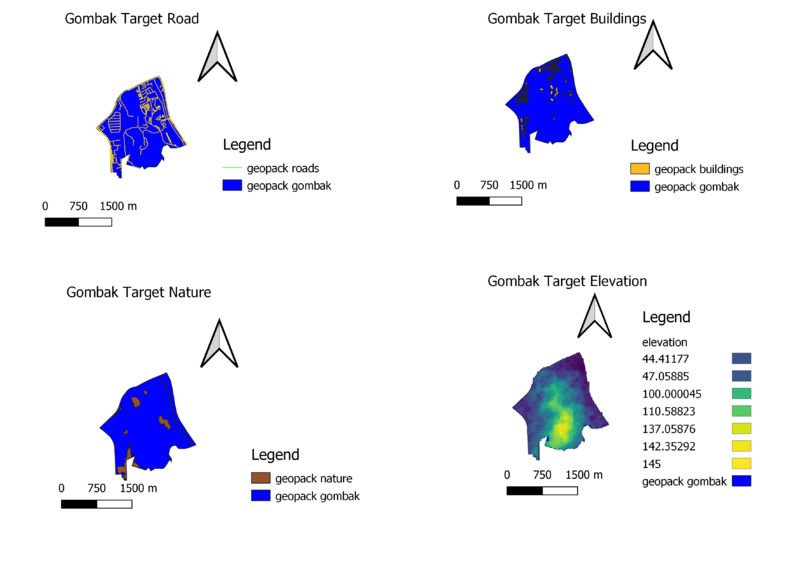
Gombak Target Road displays the major and minor roads of subzone Gombak against the study area.
Gombak Target Buildings displays all the buildings that are in subzone Gombak.
Gombak Target Nature displays all the natural features ranging from all available parks, water features and green site.
Gombak Target Elevation displays the slope elevation in subzone Gombak. The dark purple shades are lower-lying ground while the lighter the colour, the higher the ground level.
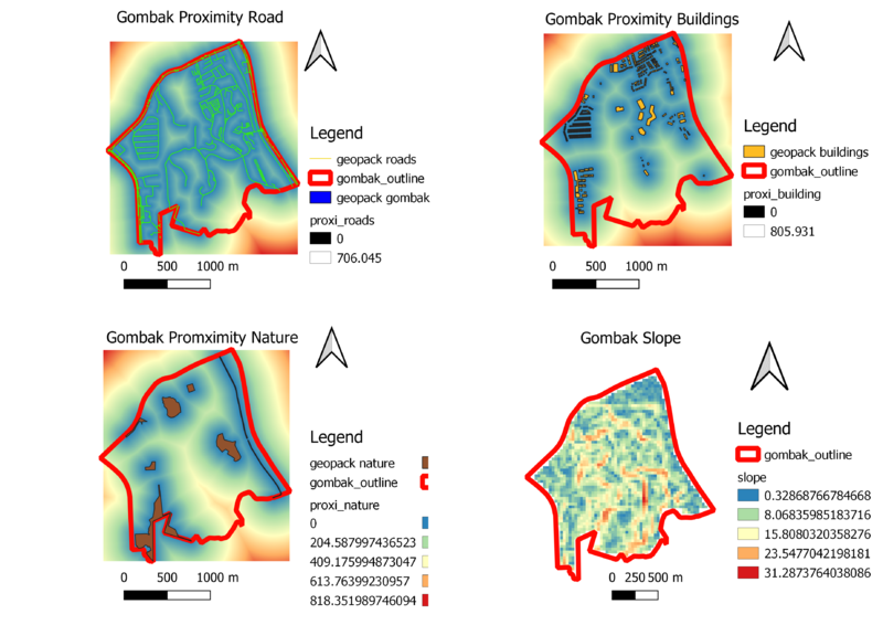
Gombak Proximity Road map illustrates the road network of Gombak in view of the Buildings in Gombak. The light blue section around the road network represents the proximity of the road to buildings. Whereas, the furthest area from the road network without buildings, are red in colour.
Gombak Proximity Buildings map illustrates the buildings in Gombak. Those darker blue sections are nearer the building. The further the area from buildings, the colour turns to a lighter green.
Gombak Proximity Nature map illustrates the natural features in Gombak. Those darker blue sections are nearer the natural features. The further the area from natural features, the colour turn to a lighter green.
Gombak Slope map illustrates the difference in elevation in the Elevation map displayed in the above section. We will be using this map to determine the most suitable location to build a Communicable Disease Centre which is to be away from high elevation area.
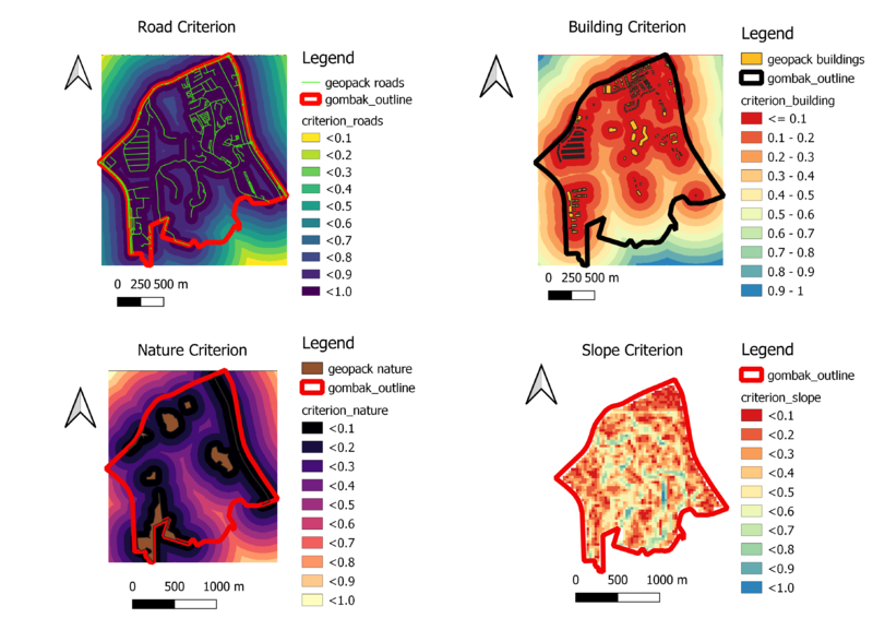
Road Criterion is the standardised criterion scores for roads. The dark purple areas have a higher score than others because it is nearer to the road network. It is optimal to build the centre near roads as it would be more accessible for people.
Building Criterion is the standardised criterion scores for buildings. The red areas have a low score because it is near buildings. This is because we would not want to place a Disease Quarantine Centre near buildings. We would not want any leakage of disease to be easily spread to the Gombak population. Therefore, the blue areas have a higher score as it is better to build our Centre in those areas to prevent a sudden widespread disease.
Nature Criterion is the standardised criterion scores for the natural features in Gombak. The dark purple areas have a lower score because according to the requirements, the Centre should be built away from those natural features. Therefore, areas further away from the natural areas have lighter colours and higher scores as those areas are more apt for our centre.
Slope Criterion is the standardised criterion score for slope. The red areas are of the lower score because there are steep slopes around that area which we do not want to build near. Therefore, those areas with light blue colours are more suitable for use and have higher scores.
AHP matrix is chosen as it has inbuilt checks and balances to ensure that you reach logically consistent solutions when you compare the relative importance the criteria in the process of assigning weights to them. In the case of Gombak, I believe that the government and citizens will place a lot of emphasis on the health risk factor as Gombak is a dense subzone which might cause a widespread of a disease once there is a leakage of bacteria. I believe that accessibility and Nature factor holds a mediocre importance level as it is not a place where citizens will visit on a regular basis. Furthermore, we should always try to preserve greenery as much as possible. However, accessibility is a bigger factor than nature as I assumed that workers will not prefer to walk through the forest to reach their working place in the Quarantine. Lastly, the consistency is at 7% which is in the acceptable range. This means that the inconsistency generated by the pairwise is still within an acceptable range.
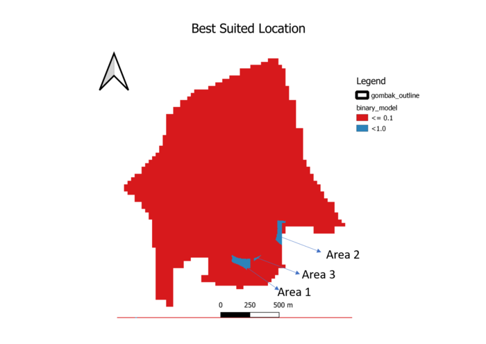
According to the image above, I decided to only focus on areas that are the best which have a score between 0.9 to 1 and the rest of the locations are not taken into consideration. The map displayed 3 potential areas for the Quarantine Center. We will pick the that is along the boundary of the subzone Gombak because as mentioned above, the health risk is the most important factor. If it is possible, we would not want to build a Quarantine Center that is being surrounded by citizens, despite it having a bigger area than any others. Therefore, I decide that area 2 is the best location to build the Quarantine Centre.


