Difference between revisions of "SMT201 AY2018-19T1 EX1 Aaron Lee Tian En"
Jump to navigation
Jump to search

| Line 2: | Line 2: | ||
=== 2014 Master Plan Landuse === | === 2014 Master Plan Landuse === | ||
| − | + | <br> | |
[[File:2014 Master Landuse.jpg|800px|center]] | [[File:2014 Master Landuse.jpg|800px|center]] | ||
Some texttfg | Some texttfg | ||
| + | === Level of Schools === | ||
[[File:Public Education Institution.jpg|800px|center]] | [[File:Public Education Institution.jpg|800px|center]] | ||
Some texttfg | Some texttfg | ||
| + | === Road Network System === | ||
[[File:Road Network System.jpg|800px|center]] | [[File:Road Network System.jpg|800px|center]] | ||
| − | + | I decided to put the Expressways as the thickest line and minor roads as the thinnest line and the 3 types of roads are different colour. This was to give a clear representation of the roads even without looking at the legend. Also, I differentiated the major and minor roads based on whether the naming had the word "road" in it. Those with the word "road" I classify them as major road. Those with "Lorong/ Jalan / street / Lane" are all classified as minor roads. | |
== Part Two: Choropleth Mapping == | == Part Two: Choropleth Mapping == | ||
| − | + | === 2014 Master Plan Landuse === | |
[[File:Aaron2010 Aged Population.png|800px|center|The Aged population of each subzone in 2010]] | [[File:Aaron2010 Aged Population.png|800px|center|The Aged population of each subzone in 2010]] | ||
| + | === 2014 Master Plan Landuse === | ||
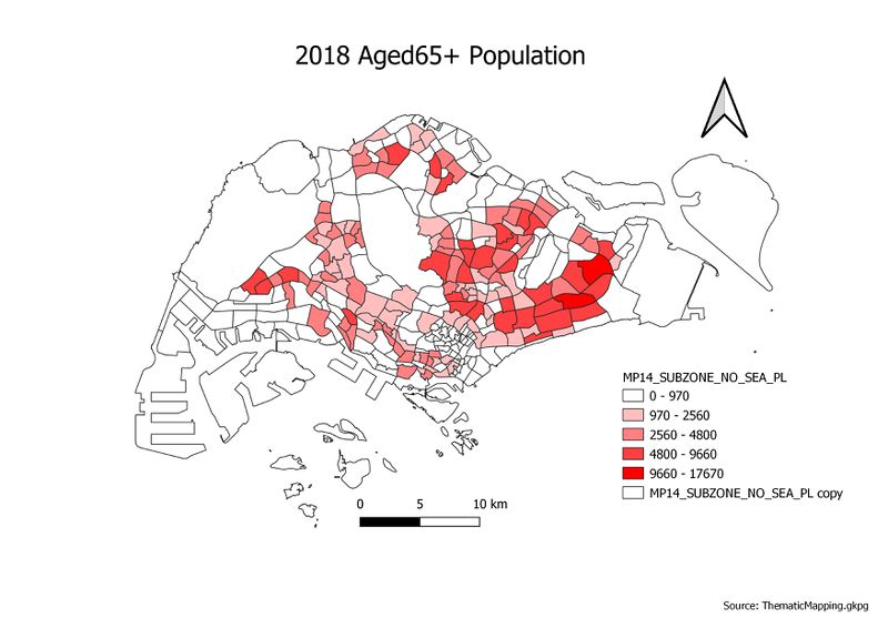
[[File:Aaron2018 Aged Population.png|800px|frameless|center|Aaron2018 Aged Population]] | [[File:Aaron2018 Aged Population.png|800px|frameless|center|Aaron2018 Aged Population]] | ||
| + | === 2014 Master Plan Landuse === | ||
[[File:Aaron2010Proportion Aged.png|800px|center|Aaron2010Proportion Aged]] | [[File:Aaron2010Proportion Aged.png|800px|center|Aaron2010Proportion Aged]] | ||
| + | === 2014 Master Plan Landuse === | ||
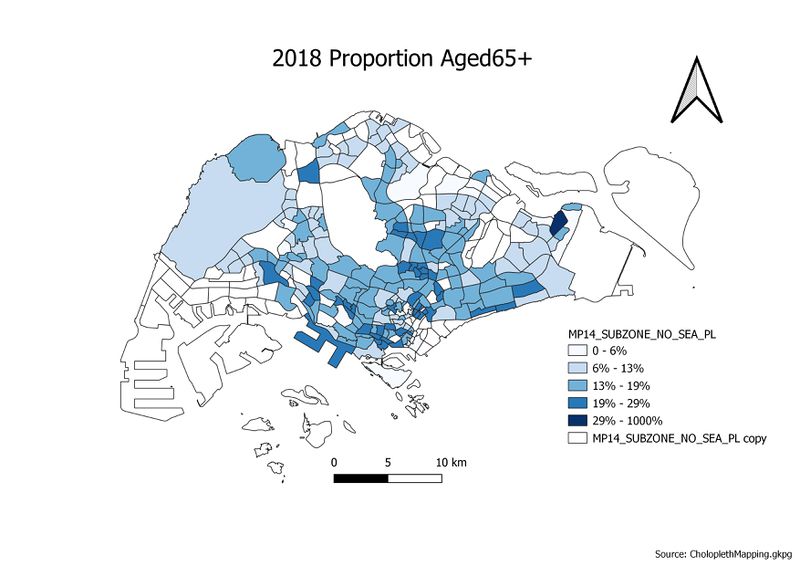
[[File:Aaron2018 Proportion Aged.png|800px|center|Aaron2018 Proportion Aged ]] | [[File:Aaron2018 Proportion Aged.png|800px|center|Aaron2018 Proportion Aged ]] | ||
| + | === 2014 Master Plan Landuse === | ||
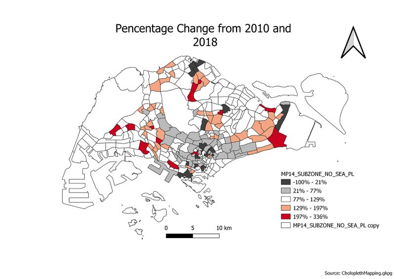
[[File:Percentage Change From 2010 and 2018.jpg|800px|center]] | [[File:Percentage Change From 2010 and 2018.jpg|800px|center]] | ||
Some texttfg | Some texttfg | ||
Revision as of 13:46, 14 September 2019
Contents
Part One: Thematic Mapping
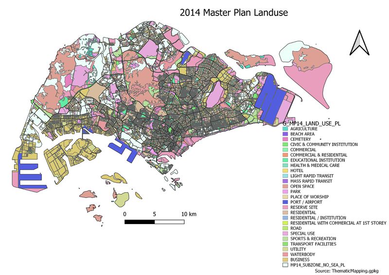
2014 Master Plan Landuse

Some texttfg
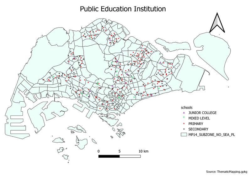
Level of Schools

Some texttfg
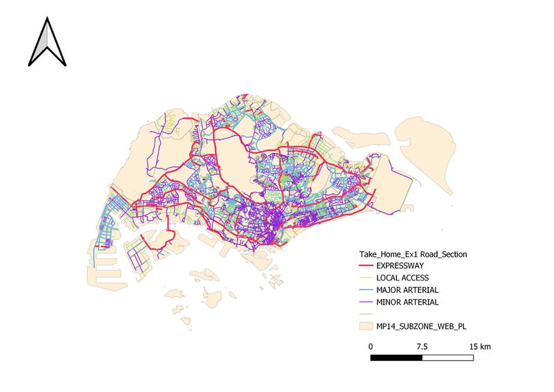
Road Network System

I decided to put the Expressways as the thickest line and minor roads as the thinnest line and the 3 types of roads are different colour. This was to give a clear representation of the roads even without looking at the legend. Also, I differentiated the major and minor roads based on whether the naming had the word "road" in it. Those with the word "road" I classify them as major road. Those with "Lorong/ Jalan / street / Lane" are all classified as minor roads.
Part Two: Choropleth Mapping
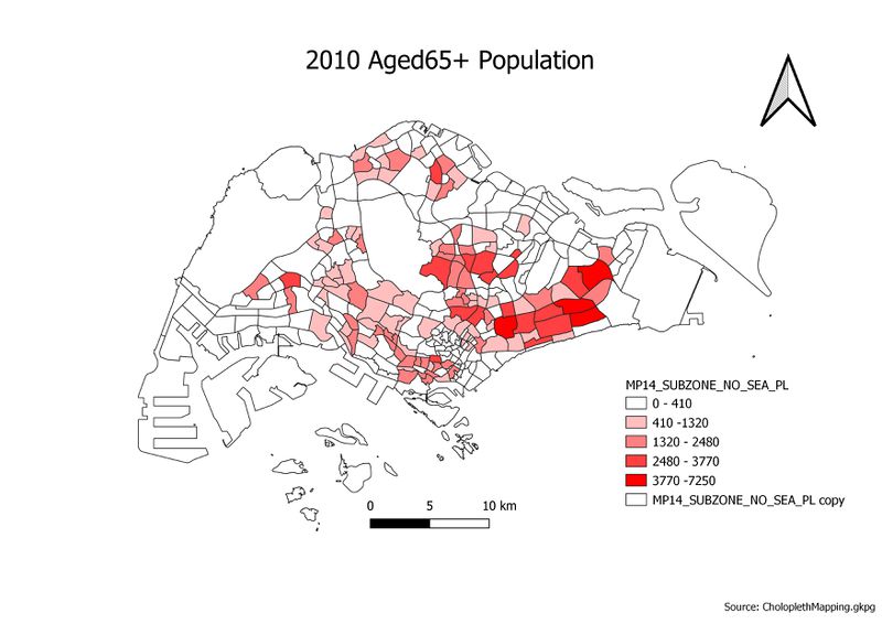
2014 Master Plan Landuse

2014 Master Plan Landuse

2014 Master Plan Landuse

2014 Master Plan Landuse

2014 Master Plan Landuse

Some texttfg