Difference between revisions of "Lesson 7"
Jump to navigation
Jump to search
| Line 53: | Line 53: | ||
==All About QGIS== | ==All About QGIS== | ||
| + | * [https://docs.qgis.org/2.14/en/docs/user_manual/working_with_raster/index.html Working with Raster Data] | ||
* [https://docs.qgis.org/2.8/en/docs/training_manual/rasters/terrain_analysis.html 8.3. Lesson: Terrain Analysis] | * [https://docs.qgis.org/2.8/en/docs/training_manual/rasters/terrain_analysis.html 8.3. Lesson: Terrain Analysis] | ||
| + | |||
== References == | == References == | ||
Revision as of 21:11, 24 September 2019
|
|
|
|
|
|
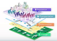
The Science of Mapthematics and Cartographic Modelling
Contents
Raster-based GIS Analysis
Introduction to Raster-based GIS Analysis
- The basic concept of raster GIS data model
- Raster database
- Characteristics of raster
- Raster resolution
- The composite weight
Map Algebra Methods
- Local functions
- Focal functions
- Neighbourhood functions
- Zonal functions
Cartographic Modelling
- A process of map analysis
All About QGIS
References
Core Reading
- Cartographic Modeling [1]
