Difference between revisions of "G2-Group11"
| (24 intermediate revisions by 2 users not shown) | |||
| Line 1: | Line 1: | ||
| + | [[File:MasterPlannerHeader.jpg|1000px|center]]</br> | ||
<!-- NAVIGATION ---> | <!-- NAVIGATION ---> | ||
| − | + | {|style="background-color:#f15a24; border:10px; border-radius:12px;" width="100%" cellspacing="0" cellpadding="0" valign="top" | | |
| − | |||
| − | + | | style="border-top:10px; border-radius:15px 0px 0px 15px; background:#A3E4D7; text-align:center;" width="20%" | | |
| − | + | [[Image: MasterPlannerHomeIcon.png|35px|link=G2-Group11_ABOUT|ABOUT]] | |
| − | |||
| + | | style="border-top:10px; border-radius:15px 0px 0px 15px; background:#F9E79F; text-align:center;" width="20%" | | ||
| + | [[Image: MasterPlannerProposalIcon.png|35px|link=G2-Group11_PROPOSAL|PROPOSAL]] | ||
| − | + | | style="border-top:10px; background:#A3E4D7; text-align:center;" width="20%" | | |
| − | + | [[Image: MasterPlannerPosterIcon.png|35px|link=G2-Group11_Poster|POSTER]] | |
| − | |||
| − | |||
| − | |||
| − | |||
| − | |||
| − | |||
| − | |||
| − | |||
| − | |||
| − | |||
| − | |||
| − | |||
| − | + | | style="border-top:10px; background:#A3E4D7; text-align:center;" width="20%" | | |
| + | [[Image: MasterPlannerReportIcon.png|35px|link=G2-Group11_Report|FINAL REPORT]] | ||
| + | |} | ||
<!-- END OF NAVIGATION ---> | <!-- END OF NAVIGATION ---> | ||
<!-- PROJECT MOTIVATION ---> | <!-- PROJECT MOTIVATION ---> | ||
| + | <div style="background:#99ccff; margin:0px; padding: 8px; text-indent: 0px; font-size:22px"><font color= #000000><p style="font-family: impact">Project Motivation</p></font></div> | ||
| − | < | + | <br><strong>The need for urban planning and analysis in Singapore</strong></br> |
| − | + | Prudent land use planning has enabled Singapore to enjoy strong economic growth and social cohesion and ensures that sufficient land is safeguarded to support continued economic progress and future development. | |
| − | + | ||
| − | + | <br><strong>Why Tampines? </strong></br> | |
| − | Prudent land use planning has enabled Singapore to enjoy strong economic growth and social cohesion and ensures that sufficient land is safeguarded to support continued economic progress and future development. | + | Tampines is a planning area and residential town in the geographical region of Tanah Merah located along the south-eastern coast of the East Region of Singapore. The planning area is bordered by Bedok and Paya Lebar to the west, Pasir Ris to the north, Changi to the east and the Singapore Straits to the south. |
| − | <br> | ||
| − | < | ||
| − | |||
| − | <br> | ||
| − | Tampines is a planning area and residential town in the geographical region of Tanah Merah located along the south-eastern coast of the East Region of Singapore. | ||
| − | |||
| − | |||
| − | |||
| − | |||
| − | |||
| − | |||
| − | |||
| − | |||
| + | Covering over 2089 hectares of land, Tampines is the third largest and third most populated new town in Singapore, following Bedok and Jurong West. As the first regional centre in Singapore, Tampines has effectively served the population in the East region, and since then Jurong and Woodlands have followed suit its success, with Seletar being the next. | ||
<!-- END OF PROJECT MOTIVATION ---> | <!-- END OF PROJECT MOTIVATION ---> | ||
<!-- PROJECT OBJECTIVE ---> | <!-- PROJECT OBJECTIVE ---> | ||
| + | <div style="background:#99ccff; margin:0px; padding: 8px; text-indent: 0px; font-size:22px"><font color= #000000><p style="font-family: impact">Project Objective</p></font></div> | ||
| + | <br><strong>1. Change report</strong></br> | ||
| + | Identifying and evaluating changes in land uses between 2008 and 2014. | ||
| + | |||
| + | <br><strong>2. Evaluation of current Master Plan</strong></br> | ||
| + | Future planning for 2024 | ||
| + | As Singapore aspires to be an age-friendly city that support and empower its residents regardless of age, our public and commercial settings and services should be made accessible to accommodate varying types of population so that we can promote diversity, inclusion and contribution in all areas of community life. With this in mind, our project aims and seeks to explore the current landscape and provide insightful analysis that is useful for future urban planning, such that it can be align with Singapore’s ongoing efforts to build an inclusive environment for all. Therefore, we will be delving deeper into the following areas: | ||
| + | *Child Care facilities for the young, | ||
| + | *Bus Stops for the economically active, and | ||
| + | *Elder Care facilities for the seniors. | ||
| − | < | + | <br><strong>3. Site selection</strong></br> |
| − | + | With our analysis on the current Master Plan, we realised that there are existing gaps in the planning of land uses as well as the potential lack of suitable amenities, and we are thus proposing new facilities as well as suitable sites to built them. | |
| − | |||
| − | |||
| − | |||
| − | |||
| − | |||
| − | |||
| − | |||
| − | |||
| − | |||
| − | |||
| − | |||
| − | |||
| − | |||
| − | |||
| − | |||
| − | |||
| − | |||
| − | |||
| − | |||
| − | |||
| − | |||
| − | |||
| − | |||
| − | |||
| − | |||
| − | |||
| − | |||
| − | |||
| − | |||
| − | |||
| − | |||
| − | |||
| − | |||
| − | With our analysis on the current Master Plan, we realised that there are existing gaps in the planning of land uses, and we are thus proposing | ||
| − | |||
| − | |||
| − | |||
| − | |||
| − | |||
| − | |||
| − | |||
<!-- END OF PROJECT OBJECTIVE ---> | <!-- END OF PROJECT OBJECTIVE ---> | ||
<!-- DATA ---> | <!-- DATA ---> | ||
| + | <div style="background:#99ccff; margin:0px; padding: 8px; text-indent: 0px; font-size:22px"><font color= #000000><p style="font-family: impact">Data</p></font></div> | ||
| − | + | {| class="wikitable" style="background-color:#FFFFFF;" width="100%" | |
| − | + | |-style= "padding: 15px;background-color:#b3b3b3;text-align: center" | |
| + | |width="20%"|<b>Data Name</b>||<b>Data Format</b>||<b>Geographic Representation</b>||width="5%"|<b>Data Source Link</b> | ||
| + | |- | ||
| + | |2008 Planning Area||Shapefile format|| style="text-align: center"|Polygon||https://data.gov.sg/dataset/master-plan-2008-planning-area-boundary-no-sea | ||
| + | |- | ||
| + | |2014 Planning Area||Shapefile format|| style="text-align: center"|Polygon||https://data.gov.sg/dataset/master-plan-2014-planning-area-boundary-no-sea | ||
| + | |- | ||
| + | |2008 Land Use||Shapefile format||style="text-align: center"|Polygon||https://data.gov.sg/dataset/mp08-land-use | ||
| + | |- | ||
| + | |2014 Land Use||Shapefile format||style="text-align: center"|Polygon||https://data.gov.sg/dataset/master-plan-2014-land-use | ||
| + | |- | ||
| + | |Singapore Residents by Planning Area, Subzone, Age Group, Sex and Type of Dwelling (June 2000-2019)||Shapefile format||style="text-align: center"|-||https://www.singstat.gov.sg/-/media/files/find_data/population/statistical_tables/singapore-residents-by-planning-areasubzone-age-group-sex-and-type-of-dwelling-june-20002019.xlsx | ||
| + | |- | ||
| + | |Bus stop Location||Shapefile format||style="text-align: center"|Point||https://www.mytransport.sg/content/mytransport/home/dataMall/search_datasets.html?searchText=bus%20stop | ||
| + | |- | ||
| + | |Eldercare Services||Shapefile format||style="text-align: center"|Point||https://data.gov.sg/dataset/eldercare-services | ||
| + | |- | ||
| + | |Child Care Services||Shapefile format||style="text-align: center"|Point||https://data.gov.sg/dataset/child-care-services | ||
| + | |- | ||
| + | |Roads||Shapefile format||style="text-align: center"|Polylines||https://download.bbbike.org/osm/bbbike/Singapore/ | ||
| + | |- | ||
| + | |Buildings||Shapefile format||style="text-align:center"|Polygon||https://download.bbbike.org/osm/bbbike/Singapore/ | ||
| + | |- | ||
| + | |ASTER Global Digital Elevation Model (GDEM)||Tagged Image File Format||style="text-align:center"|-||https://search.earthdata.nasa.gov/search?m=-7.175!25.59375!1!1!0!0%2C2 | ||
| + | |} | ||
| + | </div> | ||
<!-- END OF DATA ---> | <!-- END OF DATA ---> | ||
| + | <!-- PROJECT TIMELINE ---> | ||
| + | <div style="background:#99ccff; margin:0px; padding: 8px; text-indent: 0px; font-size:22px"><font color= #000000><p style="font-family: impact">Project Timeline</p></font></div> | ||
| + | <br> | ||
| + | [[File:MasterPlannerSlide9.png|700px|center]] | ||
| + | <br> | ||
| + | <!-- END OF PROJECT TIMELINE ---> | ||
<!-- SCOPE OF WORK ---> | <!-- SCOPE OF WORK ---> | ||
| + | <div style="background:#99ccff; margin:0px; padding: 8px; text-indent: 0px; font-size:22px"><font color= #000000><p style="font-family: impact">Scope of Work</p></font></div> | ||
| + | <br> | ||
| + | [[File:MasterPlannerSlide10.jpg|700px|center]] | ||
| − | < | + | <br> |
| − | |||
<!-- END OF SCOPE OF WORK ---> | <!-- END OF SCOPE OF WORK ---> | ||
Latest revision as of 21:07, 24 November 2019
Project Motivation
The need for urban planning and analysis in Singapore
Prudent land use planning has enabled Singapore to enjoy strong economic growth and social cohesion and ensures that sufficient land is safeguarded to support continued economic progress and future development.
Why Tampines?
Tampines is a planning area and residential town in the geographical region of Tanah Merah located along the south-eastern coast of the East Region of Singapore. The planning area is bordered by Bedok and Paya Lebar to the west, Pasir Ris to the north, Changi to the east and the Singapore Straits to the south.
Covering over 2089 hectares of land, Tampines is the third largest and third most populated new town in Singapore, following Bedok and Jurong West. As the first regional centre in Singapore, Tampines has effectively served the population in the East region, and since then Jurong and Woodlands have followed suit its success, with Seletar being the next.
Project Objective
1. Change report
Identifying and evaluating changes in land uses between 2008 and 2014.
2. Evaluation of current Master Plan
Future planning for 2024
As Singapore aspires to be an age-friendly city that support and empower its residents regardless of age, our public and commercial settings and services should be made accessible to accommodate varying types of population so that we can promote diversity, inclusion and contribution in all areas of community life. With this in mind, our project aims and seeks to explore the current landscape and provide insightful analysis that is useful for future urban planning, such that it can be align with Singapore’s ongoing efforts to build an inclusive environment for all. Therefore, we will be delving deeper into the following areas:
- Child Care facilities for the young,
- Bus Stops for the economically active, and
- Elder Care facilities for the seniors.
3. Site selection
With our analysis on the current Master Plan, we realised that there are existing gaps in the planning of land uses as well as the potential lack of suitable amenities, and we are thus proposing new facilities as well as suitable sites to built them.
Data
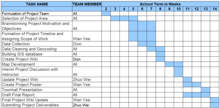
Project Timeline
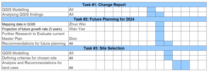
Scope of Work


