Difference between revisions of "G1-Group06 Proposal"
| Line 129: | Line 129: | ||
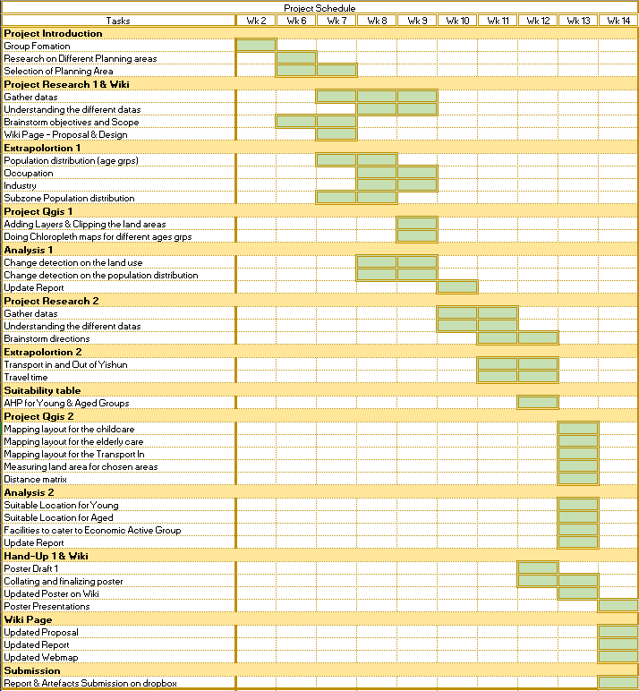
== Project Schedule == | == Project Schedule == | ||
| − | [[File:PS6 G1.png| | + | [[File:PS6 G1.png|2500px|frameless|center]] |
Revision as of 17:08, 24 November 2019
|
|
|
|
|
|
Projection Motivation
At 40 odd-years, Yishun is considered a relatively young town with an abundance of undeveloped reserve sites that show potential for further development. It is also an area of Singapore that showcases a diverse landscape consisting of natural features like large water bodies and artificial features like commercial and business buildings that coexist within the same planning area. As one of the 3 pilot towns to be rejuvenated under the Remaking out Heartland (ROH) program in September 2007, Yishun has since undergone many transformations to become the vibrant town it is today. Hence, it will be interesting to see the changes that Yishun has undergone throughout the years and it will be a rewarding experience to attempt to plan for its future.
Project Objective
Our project aims to highlight the changes in land use and population demographics from the year 2008 to 2014. We will achieve this through the comparison of land use maps and data of Yishun’s population demographics for the year 2008 and 2014. Through our study, we hope to gain insights into the decision-making process that goes behind the creation of Singapore’s master plan that is produced every 5 years. Going further, we would like to suggest changes in land use for a master plan in the year 2024. The master plan will be based on estimates of the population demographics that exist in 2024. We hope the proposed master plan will bring about an improved quality of life for the residents of Yishun in 2024.
Materials Used
| Data Filename | Description | Data Format | Source | Usage |
|---|---|---|---|---|
| GeoPackage | ||||
| GeoProject1510 | Contains all the data and vector layers in this Project | GPKG | Us | - |
| GeoProject1111 | Contains all the raster layers in this Project | GPKG | Us | - |
| Maps | ||||
| MP08_PLNG_AREA_NO_SEA_PL | Delimitation of Planning areas in Singapore in 2008 | SHP | data.gov | Yishun's Planning area in 2008 |
| MP08_SUBZONE_NO_SEA_PL | Delimitation of Subzones in Singapore in 2008 | SHP | data.gov | Subzones in Yishun in 2008 |
| MP14_PLNG_AREA_NO_SEA_PL | Delimitation of Planning areas in Singapore in 2014 | SHP | data.gov | Yishun's Planning area in 2014 |
| MP14_SUBZONE_NO_SEA_PL | Delimitation of Subzones in Singapore in 2014 | SHP | data.gov | Subzones in Yishun in 2014 |
| G_MP08_LAND_USE_PL | Allocation of landuse in 2008 | SHP | data.gov | Yishun's Land usage in 2008 |
| G_MP14_LAND_USE_PL | Allocation of landuse in 2014 | SHP | data.gov | Yishun's Land usage in 2014 |
| 2010 Basic Demographics | Population Demographics of Singapore in 2010 | .xls | Singstat | Yishun’s population numbers classified by age groups & subzones in 2010 |
| 2010 Resident Working Persons Aged 15 years and Over | Population Demographics of Singapore Resident Working Persons aged 15 years and over in 2010 | .xls | Singstat | Number of Yishun residents in each Industry and Occupation in 2010 |
| 2015 Basic Demographics | Population Demographics of Singapore in 2015 | .xls | Singstat | Yishun’s population numbers classified by age groups & subzones in 2015 |
| 2015 Resident Working Persons Aged 15 years and Over | Population Demographics of Singapore Resident Working Persons aged 15 years and over in 2015 | .xls | Singstat | Number of Yishun residents in each Industry and Occupation in 2015 |
| Singapore_Residents_by_Planning | Population Demographics of Singapore in from 2011 to 2019 | .xls | data.gov | Population size of each subzone in Yishun for every year between 2011 to 2019 inclusive |
| origin_destination_bus_201909 | Number of trips by weekdays and weekends from origin to destination bus stops in September 2019 | .csv | datamall | Volume of incoming and outgoing passengers for bus stops in Yishun in September 2019 |
| ELDERCARE | Location of Eldercare Services in Singapore | shp | data.gov | Location of Eldercare centres in Yishun |
| listing-of-centre | Directory of Childcare centres in Singapore | .csv | data.gov | Location of Childcare services in Yishun |
| buildings | Location of buildings in Singapore | shp | Open Street Maps | Location of buildings in Yishun |
| natural | Location of natural features in Singapore | shp | Open Street Maps | Location of natural features in Yishun |
| roads | Location of roads in Singapore | shp | Open Street Maps | Location of roads in Yishun |
| ASTER_GDEM_combined | Global Digital Elevation Model | .tif | Earth Data by NASA | Find elevation of land area in Yishun and do proximity study |
| sportsfieldssg | Location of all sport features in Singapore | shp | data.gov | Location of Yishun stadium |
| wateractivitiessg | Location of all water sport features in Singapore | shp | data.gov | Location of Yishun swimming complex |
| Software | Description | Data Format | Usage |
|---|---|---|---|
| QGIS | Geographic information system (GIS) software | SHP, GPKG, CSV | Analyze and Edit spatial information |
| Microsoft Excel | Raw data | CSV | Edit and extract the data to QGIS |

