File:Distribution of public education institution.png
Jump to navigation
Jump to search


Size of this preview: 800 × 566 pixels. Other resolutions: 320 × 226 pixels | 3,507 × 2,480 pixels.
Original file (3,507 × 2,480 pixels, file size: 998 KB, MIME type: image/png)
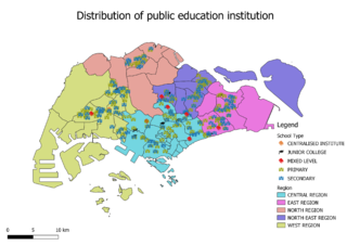
The base map is the Master Planning Subzone which will be able to split Singapore into different regions based on colour. Within the map itself, the icon of various schools and different colour are used to locate where they exist in the map based on their level.
File history
Click on a date/time to view the file as it appeared at that time.
| Date/Time | Thumbnail | Dimensions | User | Comment | |
|---|---|---|---|---|---|
| current | 20:38, 15 September 2019 | | 3,507 × 2,480 (998 KB) | Yklee.2017 (talk | contribs) |
- You cannot overwrite this file.
File usage
The following page links to this file: