Signal Proposal
Contents
- 1 PROBLEM & MOTIVATION
- 2 OBJECTIVES
- 3 SELECTED DATASETS
- 4 DATA PREPARATION
- 5 LITERATURE REVIEW
- 5.1 1. Network-constrained spatio-temporal clustering analysis of traffic collisions in Jinghan District of Wuhan, China
- 5.2 2. Visualizing Traffic Accident Hotspots Based on Spatial-Temporal Network Kernel Density Estimation
- 5.3 3. Analysis of data on the dataset of road accidents in Paris in 2012 and 2013 (http://www.remyzum.com/shiny/Paris_Accidentologie/)
- 6 APPROACH
- 7 STORYBOARD
- 8 TOOLS & TECHNOLOGIES
- 9 KEY CHALLENGES
- 10 TIMELINE
- 11 REFERENCES
- 12 COMMENTS
PROBLEM & MOTIVATION
Efforts by the Singapore Traffic Police in educating the public on road safety over the years have decreased the number of Fatal Accidents in Singapore by 15.7% in 2017 as compared to 2016 (Chua, 2018). Despite this improvement, Singapore's road fatalities per 100,000 motor vehicles of 20.2 in 2015 is still relatively high as compared to countries, such as Japan, which has achieved a low 6.5 (World Health Organisation, 2015). Accidents involving motorcyclists and elderly jaywalkers were highlighted as key concerns by the Singapore Traffic Police. This is because motorcycle accidents accounts for more than half of the traffic accidents in 2017 and the number of elderly jaywalkers road fatalities are on the rise.
Leeds, Yorkshire town of close to 800,000 people, is home to Open Data Institute Leeds which was created to explore and deliver the potential of open innovation with data at city scale. In fact, despite Leeds being a small city in England, it is well-known for housing several data-heavy institutions, commercial enterprises and academia, all which contributed to the rich public data set that Leeds offers. Not surprising, Leeds is now a hub for data activity, with some businesses handling over 30 million data events daily to uncover consumer insights (Turner, 2018). Therefore, Leeds serves as an appropriate model for Singapore, a city-state aiming to derive people-centric solutions to address urban challenges, to emulate from.
To better derive insights from traffic accidents for our project, we will be using relevant datasets, mainly from Leeds City Council and Ordnance Survey, to analyse potential factors that could correlate with road accidents. Variables such as location of shops and weather would be incorporated and the analyses would be linked to Singapore. We would also be recommending appropriate preventive and corrective measures that could be put into place by the respective authorities, such as Singapore Traffic Police and Land Transport Authority.
OBJECTIVES
In our project, we would be creating geovisualisations that are able to achieve the following objectives:
- Gain an overview of traffic accident hotspots
- Explore possible correlations with traffic accidents
- Identify zones which are more prone to accidents
- Recommend additional datasets that should be collected
SELECTED DATASETS
The following datasets will be used for analysis, as elaborated below:
| Dataset | Format | Data Attribute | Source |
|---|---|---|---|
| Leeds Road Traffic Accidents (2009 - 2017) | CSV |
|
UK Open Database |
| Local Authority Districts (Leeds) | SHP | UK Consumer Data Research Centre (CDRC) | |
| Leeds Road | SHP | UK Consumer Data Research Centre (CDRC) | |
| Leeds RoadTunnel Network | SHP | UK Consumer Data Research Centre (CDRC) | |
| Leeds Motorway Junction | SHP | UK Consumer Data Research Centre (CDRC) |
DATA PREPARATION
TO BE FILLED!
LITERATURE REVIEW
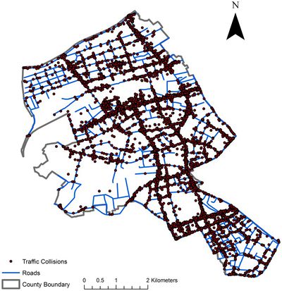
1. Network-constrained spatio-temporal clustering analysis of traffic collisions in Jinghan District of Wuhan, China
(By: Yaxin Fan, Xinyan Zhu, Bing She, Wei Guo, Tao Guo)
Aim of Study: To explore the spatio-temporal clustering patterns of traffic collisions by combining a set of network-constrained methods.
Methodology:
- Weighted network kernel density estimation
- Provides an intuitive way to incorporate attribute information
- Network cross K-function
- Shows that there are varying clustering tendencies between traffic collisions and different types of points of interests (POIs)
- Network differential Local Moran’s I and network local indicators of mobility association
- Provides straightforward and quantitative measures of the hotspot changes
Learning Points:
- Taking into consideration of contributory factors that may affect or correlate with the occurrence of traffic collisions (using network cross K-function to quantify spatial interrelationships between two types of point sets, coupled with Monte Carlo simulation method to test the distribution pattern of point events)
- Incorporated semantic information and temporal dimension of traffic collisions for comprehensive understanding of the spatio-temporal clustering patterns
- Considered POIs that might not directly relate to individual collisions but their spatial distribution might correlate with spatial distribution of collisions collectively
Areas for Improvement:
- Perhaps key implementation issues can be highlighted to allow readers to be aware of the potential drawbacks when implementing the mentioned algorithms, and to make necessary changes according to their context.
2. Visualizing Traffic Accident Hotspots Based on Spatial-Temporal Network Kernel Density Estimation
(By: Benjamin Romano, Zhe Jiang)
Aim of Study: Using Spatial-Temporal Network Kernel Density Estimation To Analyse Traffic Accidents in New York
Methodology:
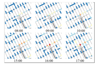
- Spatio-temporal network kernel density estimation (STNKDE)
- In Network Kernel Density Estimation, edges are split into lixels. STNKDE extends the concept of lixel to include a temporal aspect.
Learning Points:
- Use of spatial-temporal methods helps to avoid over-allocation of resources during non-peak hours
Areas for Improvement:
- Explore the use of combining Getis-Ord GI* statistics to determine if hotspots are statistically significant
- Perhaps apply the spatial-temporal aspects to other relevant methods such as Weighted Kernel Density Estimation
3. Analysis of data on the dataset of road accidents in Paris in 2012 and 2013 (http://www.remyzum.com/shiny/Paris_Accidentologie/)
(By: Remy Zumbiehl)
Aim of Study: Exploratory data analysis of road accident in Paris
Methodology:
- Basic Mapping using Leaflet Package
Learning Points:
- Using different symbol or marker to present the severity of the road accidents
- Adding filters to drill down the dataset
- Types of vehicles
- Temporal Analysis - date range, the day of the week and time frame
Areas for Improvement:
- Add in geospatial analysis such as Kernel Density Estimation and Network Constrained Analysis
APPROACH
TO BE FILLED!
STORYBOARD
TOOLS & TECHNOLOGIES
Tools and technologies
TO BE FILLED!
Data Architecture
KEY CHALLENGES
The following are some of the key technical challenges that we may face throughout the course of the project:
| Key Challenges | Mitigation Plan |
|---|---|
| Unfamiliarity with spatial analysis methods |
|
| Unfamiliarity with R and Rshiny Libraries |
|
| Unfamiliarity with Leeds geographical area |
|
TIMELINE
REFERENCES
- Chua, A. (2018, February 7). Fatal road accidents and fatalities hit all-time low in 2017: Traffic Police. Retrieved from https://www.todayonline.com/singapore/fatal-road-accidents-and-fatalities-hit-all-time-low-2017-traffic-police
- Fan, Y., Zhu, X., She, B., Guo, W. & Guo, T. (2018) Network-constrained spatio-temporal clustering analysis of traffic collisions in Jianghan District of Wuhan, China. PLoS ONE 13(4): e0195093. Retrieved from https://doi.org/10.1371/journal.pone.0195093
- Rui, Y., Yang, Z., Qian T., Khalid, S., Xia N. & Wang J. (2016) Network-constrained and category-based point pattern analysis for Suguo retail stores in Nanjing, China. Retrieved from https://doi.org/10.1080/13658816.2015.1080829
- Turner, A. (2018, November 13). How Big Data is Driving Innovation in the Leeds City Region. Retrieved from https://leeds-list.com/discussion/how-big-data-is-driving-innovation-in-the-leeds-city-region/
- Xie, Z. & Yan, J. (2008). Kernel Density Estimation of traffic accidents in a network space. Computers, Environment and Urban Systems, 32, 396-406. Retrieved from https://doi.org/10.1016/j.compenvurbsys.2008.05.001
- Yamada, I. & Thill, J. (2010). Local Indicators of Network-Constrained Clusters in Spatial Patterns Represented by a Link Attribute. Annals of the Association of American Geographers. 100. 269-285. Retrieved from https://doi.org/10.1080/00045600903550337
- Zumbiehl, R (2018, October 16). Accidentology in Paris. Retrieved from http://www.remyzum.com/shiny/Paris_Accidentologie/
COMMENTS
Feel free to leave us some comments so that we can improve!
| No. | Name | Date | Comments |
|---|---|---|---|
| 1. | Insert your name here | Insert date here | Insert comment here |
| 2. | Insert your name here | Insert date here | Insert comment here |
| 3. | Insert your name here | Insert date here | Insert comment here |

