Difference between revisions of "BURP Proposal"
Jump to navigation
Jump to search

| Line 44: | Line 44: | ||
<div style="background: #f6c630; padding: 20px; line-height: 0.3em; letter-spacing:0.1em; font-size:150%; font-weight:bold; text-align: center; margin-left: 5em; margin-right: 5em;"><font color=#000 face="Tw Cen MT">PROJECT PROTOTYPE</font></div> | <div style="background: #f6c630; padding: 20px; line-height: 0.3em; letter-spacing:0.1em; font-size:150%; font-weight:bold; text-align: center; margin-left: 5em; margin-right: 5em;"><font color=#000 face="Tw Cen MT">PROJECT PROTOTYPE</font></div> | ||
<div style= "text-align: left; padding: 20px; margin-left: 6em; margin-right: 6em;"> | <div style= "text-align: left; padding: 20px; margin-left: 6em; margin-right: 6em;"> | ||
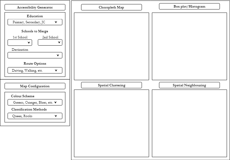
| − | + | [[File:Prototype v.1.png|1300px|frameless|center]] | |
</div> | </div> | ||
<!-- End of Project Prototype---> | <!-- End of Project Prototype---> | ||
| Line 51: | Line 51: | ||
<div style="background: #f6c630; padding: 20px; line-height: 0.3em; letter-spacing:0.1em; font-size:150%; font-weight:bold; text-align: center; margin-left: 5em; margin-right: 5em;"><font color=#000 face="Tw Cen MT">PROJECT MILESTONES</font></div> | <div style="background: #f6c630; padding: 20px; line-height: 0.3em; letter-spacing:0.1em; font-size:150%; font-weight:bold; text-align: center; margin-left: 5em; margin-right: 5em;"><font color=#000 face="Tw Cen MT">PROJECT MILESTONES</font></div> | ||
<div style= "text-align: left; padding: 20px; margin-left: 6em; margin-right: 6em;"> | <div style= "text-align: left; padding: 20px; margin-left: 6em; margin-right: 6em;"> | ||
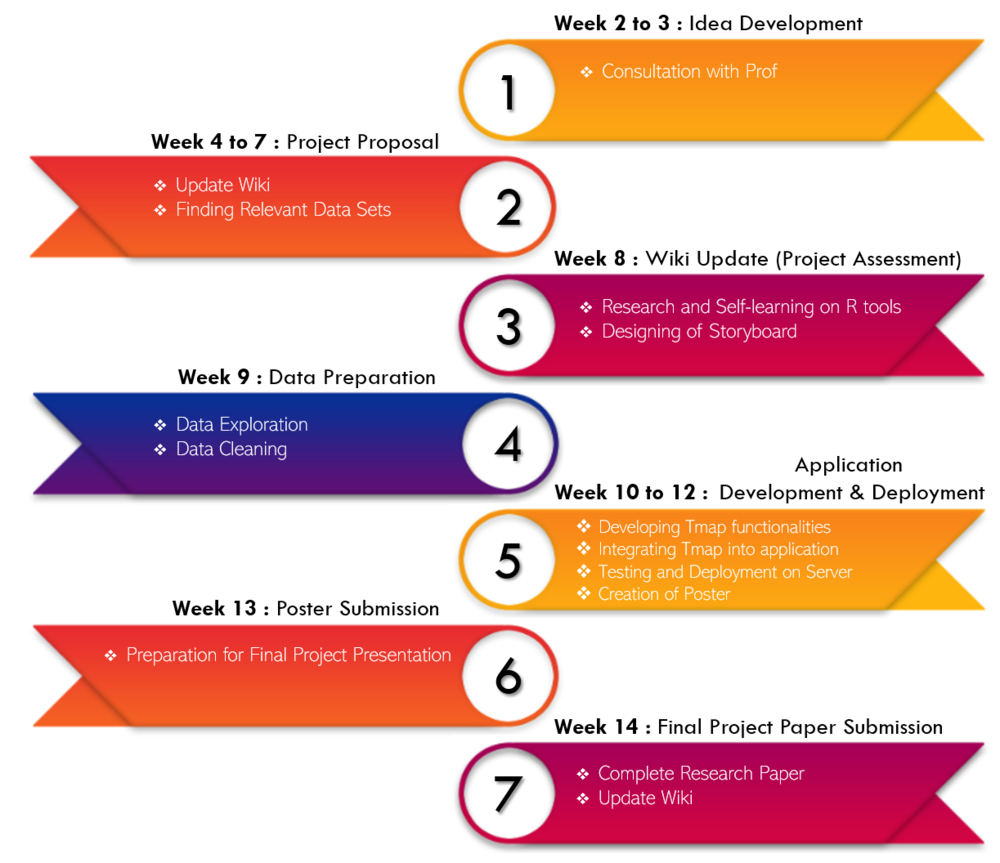
| − | [[File:BURP Milestone.png|frameless|center| | + | [[File:BURP Milestone.png|frameless|center|1000px]] |
</div> | </div> | ||
<!-- End of Project Milestones---> | <!-- End of Project Milestones---> | ||
| Line 64: | Line 64: | ||
<div style="padding: 20px; line-height: 0.3em; letter-spacing:0.1em; font-size:150%; font-weight:bold; text-align:center; margin-left: 3em; margin-right: 3em;"><font color=#000 face="Tw Cen MT">KEY CHALLENGES</font></div> | <div style="padding: 20px; line-height: 0.3em; letter-spacing:0.1em; font-size:150%; font-weight:bold; text-align:center; margin-left: 3em; margin-right: 3em;"><font color=#000 face="Tw Cen MT">KEY CHALLENGES</font></div> | ||
| − | + | {| class="wikitable" style="background-color:#FFF; margin: 1em auto; " width="80%" | |
| − | + | |+ | |
| − | </ | + | |- |
| + | ! <b>Key Challenges</b> | ||
| + | ! <b>Description</b> | ||
| + | ! <b>Solution</b> | ||
| + | |- | ||
| + | | Cross Referencing of Data | ||
| + | | As there are many datasets involved, it is difficult to cross reference the data as they are of different level. | ||
| + | | | ||
| + | #Find more data online to merge connect the different data | ||
| + | #Consult prof for advise | ||
| + | #Find for packages helps to link data | ||
| + | |- | ||
| + | | Restriction of Public Api | ||
| + | | To gather data on routes, we used public api. However, the public api do not allow us to call more than 10,000 times. | ||
| + | | | ||
| + | # Host locally to call unlimited number of times. | ||
| + | |} | ||
<!-- End of Key Challenges---> | <!-- End of Key Challenges---> | ||
| Line 72: | Line 88: | ||
<div style="background: #f6c630; padding: 20px; line-height: 0.3em; letter-spacing:0.1em; font-size:150%; font-weight:bold; text-align: center; margin-left: 5em; margin-right: 5em;"><font color=#000 face="Tw Cen MT">DATA SOURCES</font></div> | <div style="background: #f6c630; padding: 20px; line-height: 0.3em; letter-spacing:0.1em; font-size:150%; font-weight:bold; text-align: center; margin-left: 5em; margin-right: 5em;"><font color=#000 face="Tw Cen MT">DATA SOURCES</font></div> | ||
| − | {| class="wikitable" style="background-color:#FFF; margin: 1em auto;" width=" | + | {| class="wikitable" style="background-color:#FFF; margin: 1em auto;" width="80%" |
|+ | |+ | ||
|- | |- | ||
Revision as of 01:49, 28 February 2019
PROJECT DESCRIPTION
In recent years, the Ministry of Education (MOE) has been appointing new mergers between schools and relocating them. These schools include primary schools, secondary schools as well as junior colleges. The merging and relocation of schools would mean lesser schools in each neighbourhoods. This would affect the students' accessibility to certain schools, especially those in primary schools where parents need to send their children to schools. With more upcoming mergers of school by MOE, it is important for the government and schools to know the inconvenience in terms of time and distance travelled caused by the mergers and implement measures to ensure that these areas have better accessibility. Thus, our team aims to identify the HDB residential areas that are affected due to the merger of schools.
PROJECT OBJECTIVES
- Building an application that uses Geospatial to identify the accessibility of HDB residential areas to schools affected by the mergers.
PROJECT MOTIVATION
- xxx
PROJECT PROTOTYPE

PROJECT MILESTONES

TASKS ALLOCATION
- xxx
KEY CHALLENGES
| Key Challenges | Description | Solution |
|---|---|---|
| Cross Referencing of Data | As there are many datasets involved, it is difficult to cross reference the data as they are of different level. |
|
| Restriction of Public Api | To gather data on routes, we used public api. However, the public api do not allow us to call more than 10,000 times. |
|
DATA SOURCES
| Data Set | Format | Attributes |
|---|---|---|
| HDB Property Information | CSV |
|
| Postal Code Data | CSV |
|
| General Information of Schools | CSV |
|
| Route Data | CSV |
|