IS428 AY2018-19T1 Gokarn Malika Nitin
Contents
Problem and Motivation
Dataset Analysis and Transformation Process
Task 1: Spatio-temporal Analysis of Official Air Quality
Task 2: Spatio-temporal Analysis of Citizen Science Air Quality Measurements
Sensor's Coverage
I brought in the sensors for the Sofia region only, and use the Density Marks feature of Tableau 10.3 to plot the coverage of the sensors. I find that the sensors are generally placed in central Sophia, with lack of coverage in South Eastern and North Eastern regions. The number of sensors increases from 2017 to 2018, however, this is mainly concentrated in the central region, with little focus on the areas that lack coverage. Below is the coverage for the year 2018.
Sensors' Stable Operations
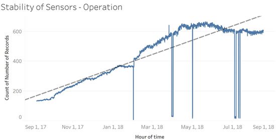
To understand whether the sensors are operating properly at all times, I looked into the time series data of the number of records being captured by the sensors over the hours. This shows that indeed the number of records and thereby sensors has increased over time. However, they are not working properly all the time, as shown by the sudden steep drop in the number of records collected and a sudden spike. Perhaps this is due to sensors suddenly not taking as many or taking too many records as compared to their configuration due to malfunction. A closer look at the time axis shows that these dips started in 2018. This could be due to the new sensors that were added in 2018. Perhaps certain members of the new group of sensors are not working correctly.
Sensors' Performance Accuracy
- Characterize the sensors’ coverage, performance and operation. Are they well distributed over the entire city? Are they all working properly at all times? Can you detect any unexpected behaviours of the sensors by analyzing the readings they capture? Limit your response to no more than 4 images and 600 words.
- Now turn your attention to the air pollution measurements themselves. Which part of the city shows relatively higher readings than others? Are these differences time-dependent? Limit your response to no more than 6 images and 800 words.
References
- Air quality index. (2018, May 04). Retrieved from https://www.eea.europa.eu/themes/air/air-quality-index/index#tab-based-on-data
- Air Quality Standards. (n.d.). Retrieved from http://ec.europa.eu/environment/air/quality/standards.htm
- Bulgaria Celebrates with Christmas Eve Traditions. (n.d.). Retrieved from https://www.novinite.com/articles/135151/Bulgaria Celebrates with Christmas Eve Traditions
- Climate - Bulgaria. (n.d.). Retrieved from https://www.climatestotravel.com/climate/Bulgaria
- Public Holidays in Bulgaria in 2018. (n.d.). Retrieved from https://www.officeholidays.com/countries/bulgaria/index.php
- Bulgaria: Kresna Gorge forest fires lead to more evacuations. (2017, August 30). Retrieved from https://sofiaglobe.com/2017/08/28/bulgaria-kresna-gorge-forestfires-lead-to-more-evacuations/
-->
Task 3
Urban air pollution is a complex issue. There are many factors affecting the air quality of a city. Some of the possible causes are:
- Local energy sources. For example, according to Unmask My City, a global initiative by doctors, nurses, public health practitioners, and allied health professionals dedicated to improving air quality and reducing emissions in our cities, Bulgaria’s main sources of PM10, and fine particle pollution PM2.5 (particles 2.5 microns or smaller) are household burning of fossil fuels or biomass, and transport.
- Local meteorology such as temperature, pressure, rainfall, humidity, wind etc
- Local topography
- Complex interactions between local topography and meteorological characteristics.
- Transboundary pollution, for example, the haze that intruded into Singapore from our neighbours.
In this third task, you are required to reveal the relationships between the factors mentioned above and the air quality measure detected in Task 1 and Task 2. Limit your response to no more than 5 images and 600 words.
Software
- Tableau - for visualization of the various tasks
- Python - for geocoding
