 VAST Challenge 2018: Suspense at the Wildlife Preserve
Data Overview
For this challenge, we were provided with the following data:
| # |
Dataset Description |
Screenshot and Metadata
|
| 1 |
Calls and songs from known birds in the Boonsong Lekagul Wildlife Preserve. They are in MP3 format with varying lengths. The file name contains the species name and an integer that can be referenced with AllBirdsv4.csv for its metadata. |
|
| 2 |
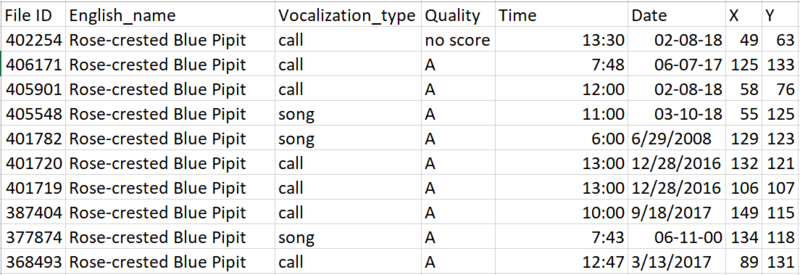
“AllBirdsv4.csv” contains metadata for the calls and songs from known birds in eight variables.
|
Screenshot of AllBirdsv4.csv
| Variable Name |
Description
|
| File ID |
The integer index of the file names for calls and songs from known birds
|
| English_name |
The common English name for the recorded bird
|
| Vocalization_type |
Type of bird sound, typically a “call” or a “song”
|
| Quality |
Quality of the recorded bird sound (A, B, C, D, E or no score). A recording with loud background noise or low bird sound purity has a lower quality.
|
| Time |
Time the recording was captured
|
| Date |
Date the recording was captured
|
| X |
X coordinate of the location the recording was captured at
|
| Y |
Y coordinate of the location the recording was captured at
| Description of each variable in AllBirdsv4.csv
|
| 3 |
Fifteen bird sound files provided by Kasios to support their claim that Rose-crested Blue Pipits are still plentiful across the Preserve. They were recorded over the past few months and are in MP3 format. The file names are integers between 1 and 15, and its metadata can be referenced with Test Bird Locations.csv. |

|
| 4 |
“Test Bird Locations.csv” contains metadata for the Kasios files in three variables.
|

|
| 5 |
“Lekagul Roadways 2018.bmp” is a 200 by 200 pixel map of the Preserve which outlines the roadways through the site. The bottom left of the map has coordinate (0,0) and the top right of the map has coordinate (199,199). Note that the alleged dumping site was centered around coordinate (148, 159) and its extent has not been thoroughly studied. |
Example
|
Banner image credit to: Marshal Hedin

