Difference between revisions of "Insights"
Alagua.2017 (talk | contribs) |
Alagua.2017 (talk | contribs) |
||
| Line 92: | Line 92: | ||
[[File:Alagu_Question3_5.png|700px|centre]] | [[File:Alagu_Question3_5.png|700px|centre]] | ||
| − | + | <br><br>As all the chemicals shown above are toxic and contaminates the water with its presence, the birds over the surface water will also be affected. But as there is not consistent data records to prove the increasing trend, the sampling of data across regions serves a necessary action by the hydrology department. | |
| + | |||
| + | <b> 3. Water Temperature Matters </b> | ||
| + | |||
| + | The water temperature even though shows a cyclic trend across the locations with the peak reading being in the months of July and August, the region Tansanee has the highest water temperature among all the regions. This relates to the fact that the dissolved oxygen might be lower comparatively in this region as they are inversely related. But the lower dissolved oxygen will be harmful for aquatic life , but it might be advantageous for birds as the algae and debris become abundant in the preserve region creating food intake for the birds. The reason for the other regions having higher dissolved oxygen might be a concern for birds as the food sources in the rivers and streams are reduced. | ||
| + | |||
| + | [[File:Alagu_Question3_6.png|700px|centre]] | ||
Revision as of 16:09, 8 July 2018
|
|
|
|
|
Question 1 :Characterize the past and most recent situation with respect to chemical contamination in the Boonsong Lekagul waterways. Do you see any trends of possible interest in this investigation?
1. Sampling pattern :
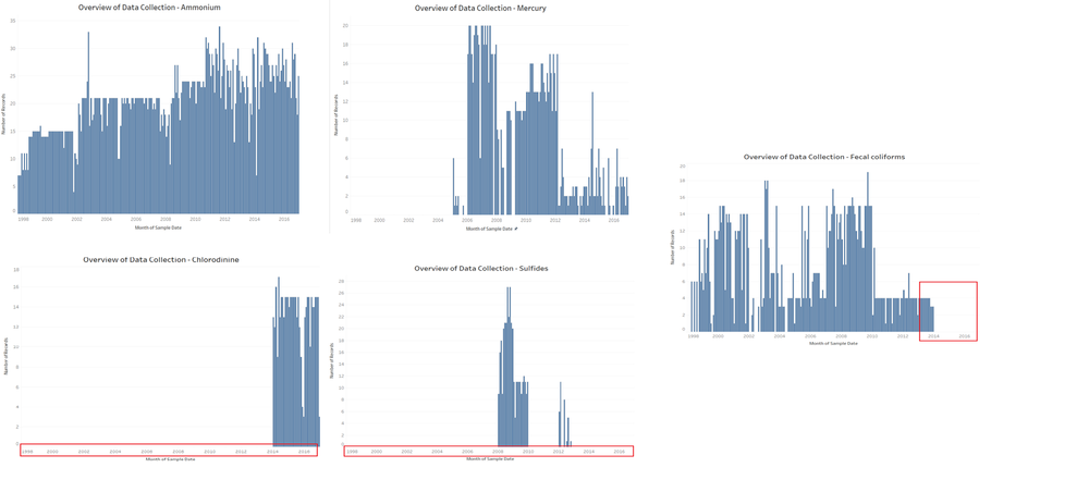
The Waterway sample readings taken by the hydrology department shows an different pattern in the data collection in the past and recent years among the chemicals. The number of records every month taken by the sensors and monitors are different for each chemical. As shown below there are broadly five categories of data collection by the hydrology department:
1. Complete Data: These chemicals have data from the year 1998 – 2016 taken by the hydrology department. Even though the number of readings are different across the years, they have the complete pattern to detect the trends and anomalies. These are chemicals like Ammonium, Magnesium, Sodium, Sulphates, Zinc , water temperature.
2. Data Available for Last few years: These chemicals have data for the last few years from 2005-2016 taken by the hydrology department.These chemicals were not considered and recorded in the years before 2005. This pattern is exhibited for the chemicals like Mercury, Total nitrogen, total hardness.
3.Data Missing for Recent years: These chemicals have data missing for the recent years from 2014-2016.This might be due to the disappearance of chemical content in recent years or the sensors and monitors dint capture the data. This pattern is exhibited for the chemicals like Fecal coliforms, Atrazine, Endrin.
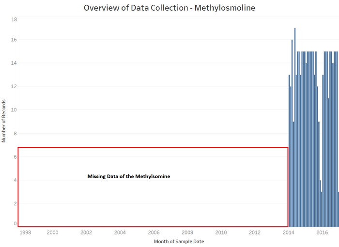
4.Data Available only for Recent years: These chemicals have data missing for the past years from 1998-2013.This suggests an possible interest in the investigation as the main toxic chemical namely Methylsomine falls in this category. Is there any reason behind not collecting the data for the past years? This pattern is exhibited for the chemicals like Chloridine, Methylsomine, Total organic carbon.
5.Sparse Data: These chemicals have data missing in between from the years 1998 - 2016.This causes the data to be sparse and also making it difficult to see the chemical contamination for these chemicals.This pattern is exhibited for the chemicals like Sulfides, Carbonates, Aluminium.
2. Time of Recordings Shows a Pattern
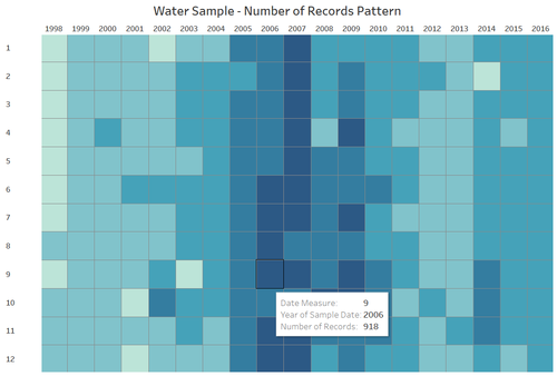
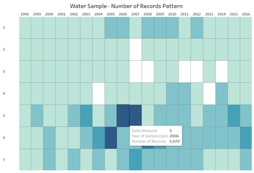
To look deeper into the trend of the hydrology samples collected in the years of 1998-2016, the heatmap below shows the popular trends of chemicals recordings. It shows an distinctive feature for the most number of records collected is more in a particular period of the time considered:
1. Year : 2006 and 2007 has been the years with most data collected by the hydrology department for all the chemical readings as a whole. Before 2006, the number of records has been very less and recent number of records show increasing sample than past situation.
2. Months: Most number of Records taken by the hydrology deparatment are in the months of September, October, November and December compared to the number of records in other months. Quarter 4 has been the most sought-after quarter for recording the chemical measure.
3. Weekday: Friday and Saturday seem to show up more record samples for the chemicals across different locations. As the reason might not be certain for this pattern , this has been the trend repeated over the years.
3. Metals Contaminate the preserve in August 2003:
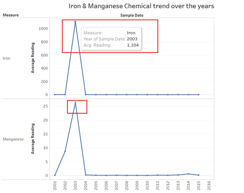
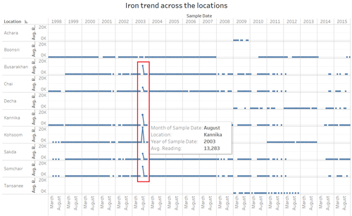
Iron has the sampling data recorded by the hydrology department over all the years from 1998 – 2015. So, looking at the trend of iron, it shows a unique increase in value in the year 2003 as the average reading goes up to 1104 mg/l. This is 1000 times higher than the average reading across all the years. According to WHO, the iron concentrations levels of 0.3 mg/litre are found acceptable in the rivers and streams. The concentration of chemical content in the year 2003 is 3000 times more than the permissible level.
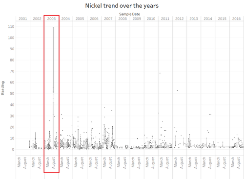
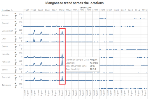
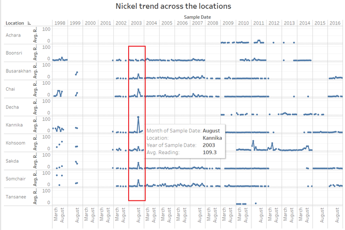
Similarly, another chemical Manganese which has readings recorded in the years 1998-2015 the average reading peaks nearly 4 times in the year 2003. According to WHO, the iron concentrations levels of 0.4 mg/litre are found acceptable in the rivers and streams. The concentration of chemical content in the year 2003 is 70 times more than the permissible level.As the Nickel doesn’t have complete data from 1998 – 2015, the box plot is created to show the readings trend over the years as shown below. The median value of Nickel in the year 2003 show 41.7 mg/L.
Looking deep into the cycle plot trend across locations for iron, nickel and manganese, the average value is high overall in all the locations (whichever location had hydrology data collected) except Boonsri in the Year 2003 specifically in the month of August. This suggests that there has been the iron, nickel and manganese chemical contamination across the preserve in the August 2003 period causing harm to the wildlife. These metal contaminations would make the rivers and stream unsuitable for both the aquatic and wildlife around the preserve.
4. Cyclic Trend
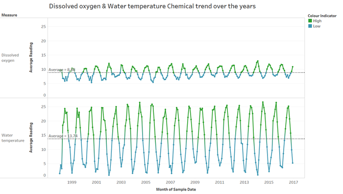
The water temperature and dissolved oxygen has been showing up inverse relationship throughout the years in the readings measure as shown below. The average readings in a month show the trend that the months the water temperature is high , the dissolved oxygen has been low across the preserve. The colour indicator even shows the green colour where they are above the average readings. In the months of July and August, the water temperature is high and consequently the dissolved oxygen is low in the rivers and streams.
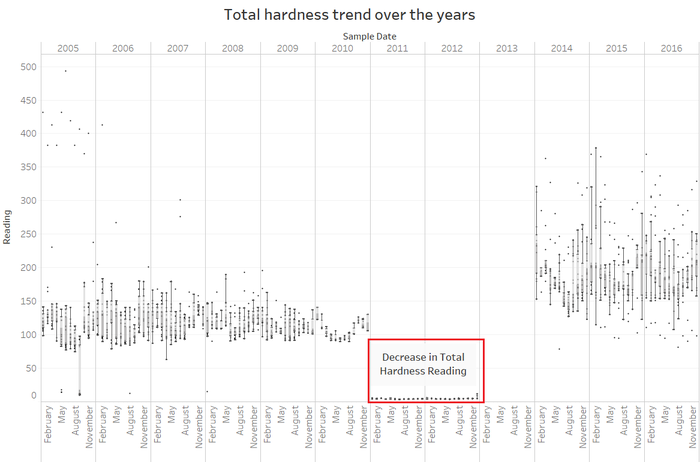
5. Total Hardness Showing Fluctuations The total Hardness has last few years data from 2005 to 2016. The median reading of total hardness has been around 117.7 µg/L in 2010 but all the readings in the preserve decreased to below 5 µg/L in the years 2011 and 2012. The median readings over the preserve has again increased in the years 2014 to 2016. The year 2013 doesn’t have any chemical reading value taken by the hydrology which has been shown in the graph below. So the total hardness has been showing an increasing trend in the preserve in the recent years 2014-2016 compared to the past situation.
Question 3 :After reviewing the data, do any of your findings cause particular concern for the Pipit or other wildlife? Would you suggest any changes in the sampling strategy to better understand the waterways situation in the Preserve?
1. Presence of Methylsomine – Area of Concern: Even though the soil samples taken from the preserve dint show any evidence of presence of Methylosmolene (the toxic manufacturing chemical in the suspected dumping) as the new soil has been tucked in, the water samples provides evidence for the justification of the presence of toxic in the preserve that might have negative effects in the wildlife and Blue Pipit birds.
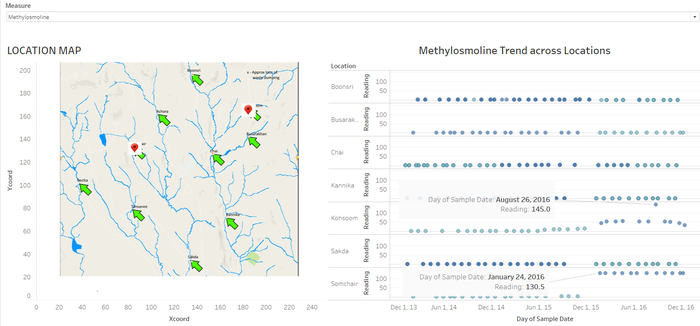
As shown in the above picture, the methylosmoline has been with low values over the period of 2014 and 2015 in all locations, they have started showing increase in values from reading 15 mg/L to 45 mg/L in the Kohsoom region and from reading 4.5 mg/L to 130.5 mg/L in Somchair in the early January 2016. Apart from the increase , the Kohsoom region also shows the peak of Methylosmoline going up to 145 mg/L on August 26,2016. This may be due to the pollutants from the factory being high in this period , this region being the area close to the dumping region there is high probability for the chemical to be the root cause. This is an area of concern for the Blue Pipit Birds around the locations Kohsoom and Somchair.
The chemical recordings for this chemical is available only for the yeas 2014 – 2016 and the data is missing for the previous years. Apart from that, looking at above graph, the data is not consistently available for 2014 and 2016 all days, the readings are missing for the months November and December in Somchair in 2016. If the sampling is done better with conisistent readings across the locations for consiisten period of time, the hydrology department can justify the presence of Methylsolmoline in the preserve that harms the wildlife.
2. Increasing Chemical Presence but lacks data to prove:
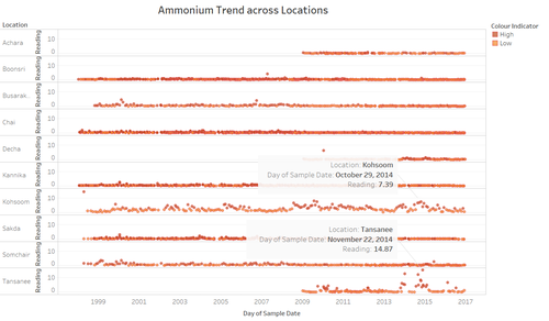
There are few chemicals like ammonium, arsenic and cyanides whose values has been showing different pattern in few locations in the preserve. Ammonium has been showing increasing trend in the readings captured by the hydrology department in recent years in the Kohsoom and Tansanee regions. The readings has been less than 2 mg/l throughout the years the samples were recorded, but the resding has jumped upto 7.39 mg/L in Kohsoom and 14.87 mg/L in Tansanee in the year 2014.
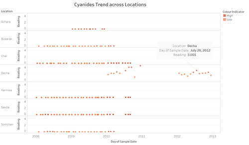
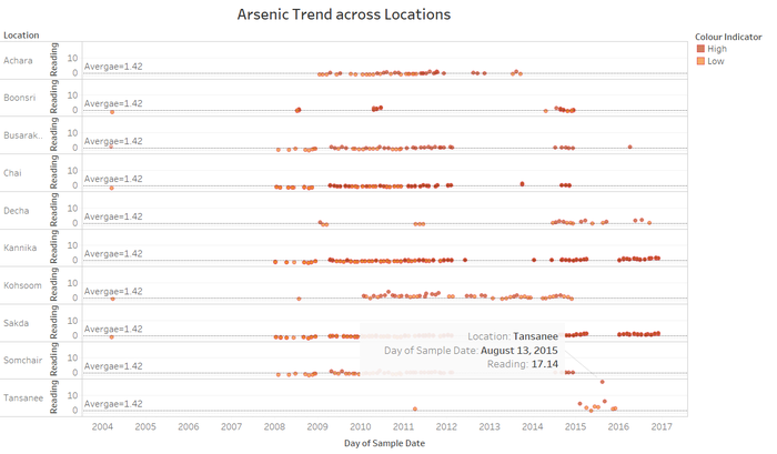
Cyanides have been below the average reading value throughout the years for all locations, but in decha region alone they have been increasingly higher compared to other regions with readings around 3 mg/L. The arsenic values in tansanee has been a unique distinctive in the pattern observed with the recent readings, they have a high value of about 17.14 above the average reading observed over the years.
As all the chemicals shown above are toxic and contaminates the water with its presence, the birds over the surface water will also be affected. But as there is not consistent data records to prove the increasing trend, the sampling of data across regions serves a necessary action by the hydrology department.
3. Water Temperature Matters
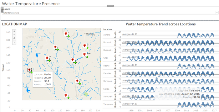
The water temperature even though shows a cyclic trend across the locations with the peak reading being in the months of July and August, the region Tansanee has the highest water temperature among all the regions. This relates to the fact that the dissolved oxygen might be lower comparatively in this region as they are inversely related. But the lower dissolved oxygen will be harmful for aquatic life , but it might be advantageous for birds as the algae and debris become abundant in the preserve region creating food intake for the birds. The reason for the other regions having higher dissolved oxygen might be a concern for birds as the food sources in the rivers and streams are reduced.

