Difference between revisions of "ISSS608 2017-18 T3 Assign Weijie Jay Zheng"
| Line 33: | Line 33: | ||
| − | + | == Mini Challenge 2 - What do we have and what do we want to find out == | |
| − | |||
| − | |||
| − | ==Mini Challenge 2 - What do we have and what do we want to find out | ||
2 Datasets are provided by Mistford College Hydrology<br /> | 2 Datasets are provided by Mistford College Hydrology<br /> | ||
- Boonsong Lekagul Waterway Readings<br /> | - Boonsong Lekagul Waterway Readings<br /> | ||
| − | - Chemical Units of Measures | + | - Chemical Units of Measures<br /> |
| + | |||
In addition, the College has also provided a map of the Preserve with named sampling sites indicated on the map. | In addition, the College has also provided a map of the Preserve with named sampling sites indicated on the map. | ||
| Line 45: | Line 43: | ||
- Characterize the past and most recent situation with respect to chemical contamination in the Boonsong Lekagul waterways.<br /> | - Characterize the past and most recent situation with respect to chemical contamination in the Boonsong Lekagul waterways.<br /> | ||
- Any anomalies from the dataset? How does it affect the analysis?<br /> | - Any anomalies from the dataset? How does it affect the analysis?<br /> | ||
| − | - Would any of the finders cause particular concern for the Pipit or other wildlife. | + | - Would any of the finders cause particular concern for the Pipit or other wildlife.<br /> |
| + | |||
All the dataset and maps have been incorporated into Tableau available via: [https://public.tableau.com/profile/jay8819#!/vizhome/MC2-WJZSolution/Dashboard1?publish=yes WJZ's MC2 Tableau]<br /> | All the dataset and maps have been incorporated into Tableau available via: [https://public.tableau.com/profile/jay8819#!/vizhome/MC2-WJZSolution/Dashboard1?publish=yes WJZ's MC2 Tableau]<br /> | ||
| Line 52: | Line 51: | ||
| − | 1. The Map | + | === 1. The Map === |
The map provides a few key infomation<br /> | The map provides a few key infomation<br /> | ||
- the location of dump waste<br /> | - the location of dump waste<br /> | ||
| Line 65: | Line 64: | ||
| − | 2. The Dataset - Readings | + | === 2. The Dataset - Readings === |
<p>[[File:GYF_timeframe.png|250px|center]]</p> | <p>[[File:GYF_timeframe.png|250px|center]]</p> | ||
| − | 3. The Cars | + | === 3. The Cars === |
<p>[[File:gyf_cars.png|200px|center]]</p> | <p>[[File:gyf_cars.png|200px|center]]</p> | ||
| − | 4. The Visitors | + | === 4. The Visitors === |
The visitors were segmented as follows based on the nature of their movements in the reserve. | The visitors were segmented as follows based on the nature of their movements in the reserve. | ||
<p>[[File:gyf_m_1.png|400px|center]]</p> | <p>[[File:gyf_m_1.png|400px|center]]</p> | ||
| Line 77: | Line 76: | ||
<p>[[File:gyf_m_10.png|400px|center]]</p> | <p>[[File:gyf_m_10.png|400px|center]]</p> | ||
| − | 5. The Data | + | === 5. The Data === |
<br> Timestamp: the date and time the sensor reading was taken | <br> Timestamp: the date and time the sensor reading was taken | ||
<br> Car-id: the assigned car ID from the entry gate | <br> Car-id: the assigned car ID from the entry gate | ||
Revision as of 20:30, 8 July 2018
Link to go back to MITB class page
VAST Challenge 2018: Suspense at the Wildlife Preserve
|
|
|
|
|
Stop Polluting the Boonsong Lekagul Wildlife Preserves
In MC Challenge 2017, the Kasios Furniture Company was implicated in environment damage to the Boonsong Lekagul Wildlife for both dumping toxic waste and polluting the air with chemicals from its manufacturing process.(MC2 Challenge Overview). The soil has since not been able to use for evidence, as construction work was conducted on the site.
With a hope to find out alternative evidence for Kasio's environment damage, the Mistford College Hydrology Department has provided a dataset of water sensor readings from rivers and streams in the preserve. The assignment is simple and clear - analyse the dataset to find any evidence to support the claim against Kasio's environment damage.
Contents
Mini Challenge 2 - What do we have and what do we want to find out
2 Datasets are provided by Mistford College Hydrology
- Boonsong Lekagul Waterway Readings
- Chemical Units of Measures
In addition, the College has also provided a map of the Preserve with named sampling sites indicated on the map.
3 major focuses of the study
- Characterize the past and most recent situation with respect to chemical contamination in the Boonsong Lekagul waterways.
- Any anomalies from the dataset? How does it affect the analysis?
- Would any of the finders cause particular concern for the Pipit or other wildlife.
All the dataset and maps have been incorporated into Tableau available via: WJZ's MC2 Tableau
1. The Map
The map provides a few key infomation
- the location of dump waste
- the sampling point
- the streams of waterflow
The information above will help form an understanding the business context
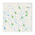
Preserve Waterway Map

2. The Dataset - Readings
3. The Cars
4. The Visitors
The visitors were segmented as follows based on the nature of their movements in the reserve.
The graph below shows the composition of each cluster by car types.
5. The Data
Timestamp: the date and time the sensor reading was taken
Car-id: the assigned car ID from the entry gate
Car-type: Vehicle type as enumerated above. “P” is appended when it is a park vehicle
Gate-name: name of the sensors taking the reading. See the map
6. The Reserve Map