Difference between revisions of "ISSS608 2017-18 T3 Assign Kalai Selvi Methodology and Dashboard Design"
Kalaisr.2017 (talk | contribs) |
Kalaisr.2017 (talk | contribs) |
||
| Line 125: | Line 125: | ||
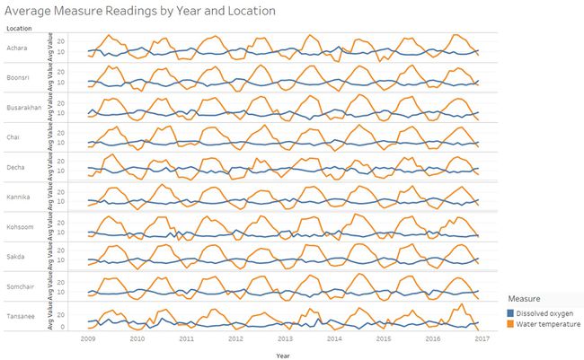
The chart below shows the cyclic trend in the average water temperature values and dissolved oxygen levels across the locations over the last 8 years. The alternating trend shows that as the water temperature increases, the dissolved oxygen level decreases. Higher temperature reduces the solubility of dissolved oxygen, hence reducing the dissolved oxygen levels. The increasing trend in water temperature is very harmful to many aquatic life animals such as fish as solubility of many toxic chemicals increases with higher temperatures and higher temperature also catalyses growth of fungus and algae. | The chart below shows the cyclic trend in the average water temperature values and dissolved oxygen levels across the locations over the last 8 years. The alternating trend shows that as the water temperature increases, the dissolved oxygen level decreases. Higher temperature reduces the solubility of dissolved oxygen, hence reducing the dissolved oxygen levels. The increasing trend in water temperature is very harmful to many aquatic life animals such as fish as solubility of many toxic chemicals increases with higher temperatures and higher temperature also catalyses growth of fungus and algae. | ||
<br> | <br> | ||
| − | [[File:32.JPG| | + | [[File:32.JPG|650 px]] |
<font size="3"><font face=""Calibri" color="#008744">Increasing Trends in Nickel'''</font></font><br> | <font size="3"><font face=""Calibri" color="#008744">Increasing Trends in Nickel'''</font></font><br> | ||
| Line 136: | Line 136: | ||
* In the Boonsong Lekagal waterway map below, most of the water sensors are located in around the labels 1 and 2 and not uniformly distibuted. There are only 2 waterway sensors, 1 in each of the waterways (Waterways labelled 1 and 2). More waterway sensors needs to be installed for the two waterways located in the left to ensure even distribution of waterway sensors. | * In the Boonsong Lekagal waterway map below, most of the water sensors are located in around the labels 1 and 2 and not uniformly distibuted. There are only 2 waterway sensors, 1 in each of the waterways (Waterways labelled 1 and 2). More waterway sensors needs to be installed for the two waterways located in the left to ensure even distribution of waterway sensors. | ||
| − | [[File:31.JPG| | + | [[File:31.JPG|400 px]] |
* A review can be conducted of the locations to ensure that the locations yield accurate sample measure readings that are representative of the waterway system. | * A review can be conducted of the locations to ensure that the locations yield accurate sample measure readings that are representative of the waterway system. | ||
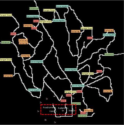
* All the 4 factories are located in the bottom center of the map. There should be more waterway sensors located close to the water outlet from these factories to capture the contaminants release from factory discharge. | * All the 4 factories are located in the bottom center of the map. There should be more waterway sensors located close to the water outlet from these factories to capture the contaminants release from factory discharge. | ||
| − | [[File:34.JPG| | + | [[File:34.JPG|400 px]] |
Revision as of 15:03, 8 July 2018
Contents
- 1 Question 1: Characterize the past and most recent situation with respect to chemical contamination in the Boonsong Lekagul waterways. Do you see any trends of possible interest in this investigation?
- 2 Question 2a: What anomalies do you find in the waterway samples dataset? How do these affect your analysis of potential problems to the environment?
- 3 Question 2b: Is the Hydrology Department collecting sufficient data to understand the comprehensive situation across the Preserve?
- 4 Question 2c: What changes would you propose to make in the sampling approach to best understand the situation?
- 5 Question 3a: After reviewing the data, do any of your findings cause particular concern for the Pipit or other wildlife?
- 6 Question 3b: Would you suggest any changes in the sampling strategy to better understand the waterways situation in the Preserve?
Question 1: Characterize the past and most recent situation with respect to chemical contamination in the Boonsong Lekagul waterways. Do you see any trends of possible interest in this investigation?
Cyclic Trends in Average Monthly Dissolved Oxygen and Water Temperature Readings observed across the years
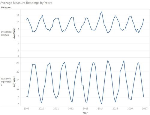
The average monthly dissolved oxygen levels and water temperature readings display alternating cyclical trends around the same period for each year. Average monthly dissolved oxygen levels in the waterways consistently declines from January to July/August and increasing trend is observed from August to December for each year. On the other hand, increasing trends in monthly average water temperature readings is observed from January to August and decreasing trend is observed from August to December for each year.
Consistent Patterns for Petroleum Hydrocarbons levels across locations
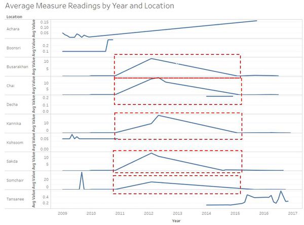
There was increasing trend in the average monthly Petroleum hydrocarbons levels from November 2010 to around February 2012 for Busarakhan, Somchair and Tansanee and an upwards trend from November 2010 to May 2012 for Chai and Kannika locations. After the upward spike in 2012, a decreasing trend was seen in the average monthly Petroleum hydrocarbons levels around the same period and the average monthly Petroleum hydrocarbons levels remained stagnant at a very low level (close to 0 mg/l) for all 5 locations.
Consistent Patterns for Nickel levels across locations
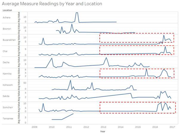
Since 2011, the average monthly Nickel measure levels follows the same pattern for Busarakhan, Chai, Kannika, Sakda and Somchair. There was a sharp spike in the average monthly Nickel levels in the first half of 2016.
Decreasing Trends in Chlorodinine levels
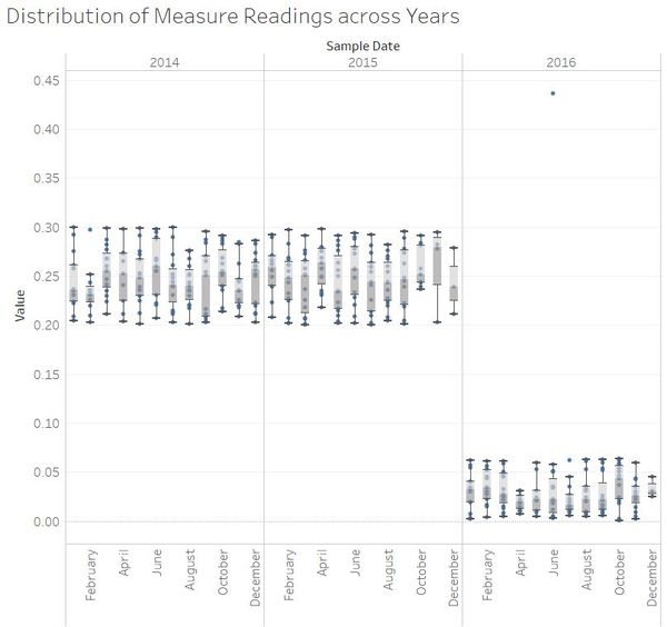
The Chlorodinine levels has been consistent for 2014 and 2015. The Chlorodinine levels recorded in 2016 are much lower compared to 2014 and 2015. The range of Chlorodinine values were more spread out in 2014 and 2015 as seen from the wider inter quartile range (IQR) of the boxplots in 2014 and 2015.
Increasing Trends in Total Hardness levels
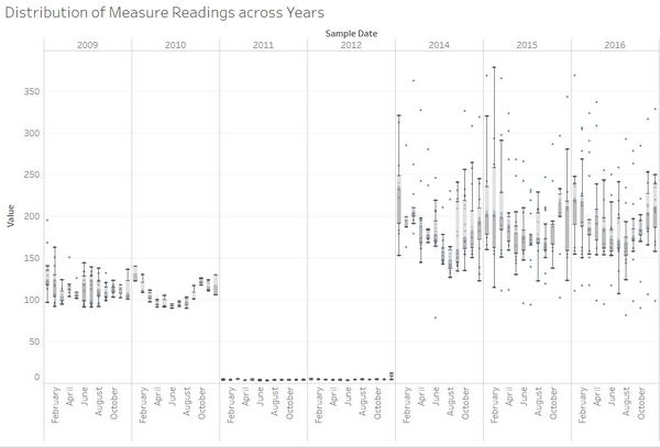
Total hardness levels have been generally declining from 2009 to 2010, and the value of the readings are closer in range in 2010 as seen with the smaller IQR. The total hardness levels were lowest in 2011 and 2012. Increasing trends in the total hardness levels were observed for 2014 to 2016 and the first quartile of the boxplots are also at a higher value in 2014 to 2016 compared to previous years. There were more highly skewed total hardness readings in 2014 to 2016 as seen with the increase in outliers.
Question 2a: What anomalies do you find in the waterway samples dataset? How do these affect your analysis of potential problems to the environment?
The anomalies are as follows and more details on the anomalies are illustrated below:
1. Inconsistent Number of Measure Records and Irregular Collection of Records across time
2. Spike in Methylosmoline levels
3. Spike in Water Temparature readings in Chai
4. Trends in Biochemical and Chemical oxygen Demand (Cr) levels
5. Spike in Iron Levels across Locations
Inconsistent Number of Measure Records and Irregular Collection of Records acorss time
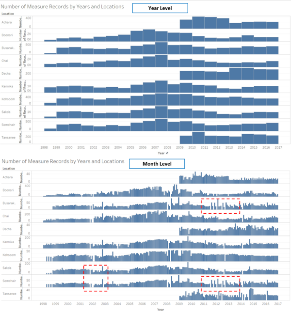
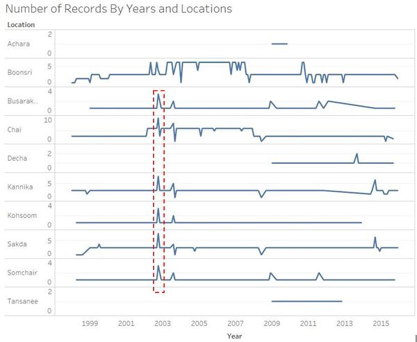
The number of records for each locations is not consistent. Some years have higher number of records compared to others. In Boonsri, Busarak, Chai, Kannika, Kohsoom, Sakda and Somchair, the highest number of measurements were recorded in 2015 to 2017. The time period in which chemical measures are collected are not consistent as chemical measures were only recorded from 2009 for Achara, Decha and Tasanee locations. In the 2nd chart below, we can observe that when we drill down by month level, the measure collection is not consistent as measures for certain months/days are not captured.
Spike in Methylosmoline levels
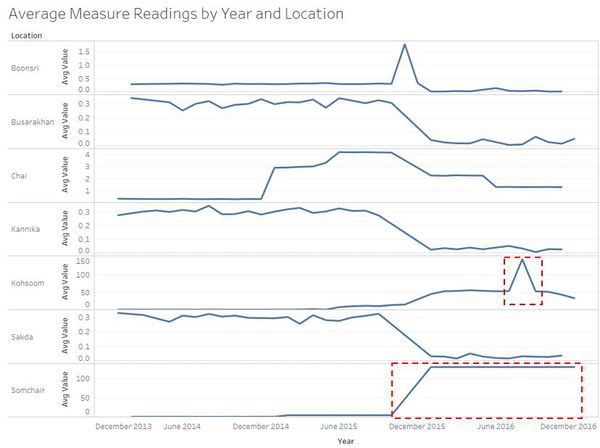
While the average Methylosmoline monthly levels are gradually decreasing from 2015, there is a sudden steep spike in the average Methylosmoline monthly levels in Somchair to a average value of 130.5 ug/l in January 2016 from 4.5 ug/l in October 2015. This sudden spike is strange as no Methylosmoline readings captured in Somchair for November and December 2015. The average monthly Methylosmoline has remain constant throughout 2016. Even drilling at the day level readings, the daily Methylosmoline level has remained stagnant throughout 2016. In Aug 2016, a sudden spike in average Methylosmoline level was also observed in Kohsoom. The constant value in 2016 is an anomaly and it may misrepresent the actual Methylosmoline levels for 2016.
Spike in Water Temparature readings in Chai
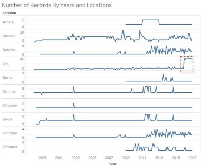
The number of water temperature readings taken at Chai has been consistent since 1998 till end of 2015. However, there was a sharp increase in the number of water temperature readings in Chai for 2016. It could be seen from the calender view chart that more readings were recorded over the weekend for water temperature readings in Chai, therefore the inconsistency in the number of readings recorded over the locations is an anomaly.
Trends in Biochemical and Chemical oxygen Demand (Cr) levels
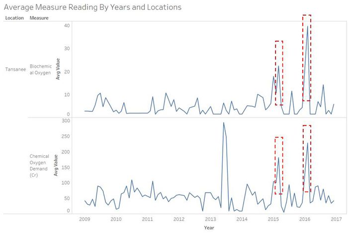
There were 2 sharp spikes in Mar 2015 and February 2016 in Tansanee location for the Chemical oxygen Demand (Cr) and Biochemical Oxygen. The 2 spikes specifically occurred on the same day for both these chemicals (20 March 2015 and 17 February 2016). Further investigation is required to find out the reasons for the spikes given that the trend for both chemicals has been consistent across the period.
Spike in Iron Levels across Locations
Iron levels recorded are very low and almost constant across the years in all locations. However, an unusual spike is recorded in August 2003 in most locations and average iron levels were above 10,000 mg/l in Busarakhan, Kanika, Kohsoom and Somchair in August 2003. Drilling down to day level, this spike has occurred on 15 August 2003 in Busarakhan, Chai, Decha, Kanika, Kohsoom, Sakda ad Somchair. This huge spike in the Iron readings poses a threat to the wildlife and investigations need to be conducted to check if there was any error in the measuring equipment or this was a genuine spike in iron levels.
Potential Problems to the Environment due to Anomalies
- If the number of records collected is not consistent across locations, this may under represent the actual chemical contamination for certain locations and the chemical contamination across locations will not be comparable.
- There is not standard timeframe frequency for the measure collection and it is difficult to study the chemical contamination in locations across time with the irregular measure collection interval.
Question 2b: Is the Hydrology Department collecting sufficient data to understand the comprehensive situation across the Preserve?
No, sufficient data is not collected. The inconsistency records and irregular collection of chemical measurements makes it harder to understand and analyse the chemical contamination measurement in detail. With limited records for certain locations, it is difficult to analyse the contamination over a time period.
Question 2c: What changes would you propose to make in the sampling approach to best understand the situation?
- The number of records captured should be consistent across locations.
- The interval in which measures are collected should be regular to ensure that the chemical contamination can be compared over time.
- If there are sudden or suspicious spikes in the measures, this should be investigated to ensure if there is a genuine spike or it could be due to fault in the measuring tool.
Question 3a: After reviewing the data, do any of your findings cause particular concern for the Pipit or other wildlife?
Increasing Trends in Water Temperature
The chart below shows the cyclic trend in the average water temperature values and dissolved oxygen levels across the locations over the last 8 years. The alternating trend shows that as the water temperature increases, the dissolved oxygen level decreases. Higher temperature reduces the solubility of dissolved oxygen, hence reducing the dissolved oxygen levels. The increasing trend in water temperature is very harmful to many aquatic life animals such as fish as solubility of many toxic chemicals increases with higher temperatures and higher temperature also catalyses growth of fungus and algae.
Increasing Trends in Nickel
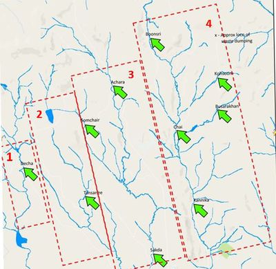
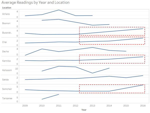
There is an increasing trend in the Nickel levels for locations Boonsri, Busarakhan, Kannika, Kohsoom and Sakda. These locations are close to the dumping site as seen in the map below and this seems to suggest that the flowed downstream from the dumping site. The increasing level of Nickel contamination over the recent years is detrimental as Nickel is considered as a important and persistent chemical pollutant in the aquatic environment; affecting survival of fish and other aquatic animals. Pipits could also be affected when they drink water from the waterways that are contaminated with algae and other toxic chemicals such as Nickel.
Question 3b: Would you suggest any changes in the sampling strategy to better understand the waterways situation in the Preserve?
- In the Boonsong Lekagal waterway map below, most of the water sensors are located in around the labels 1 and 2 and not uniformly distibuted. There are only 2 waterway sensors, 1 in each of the waterways (Waterways labelled 1 and 2). More waterway sensors needs to be installed for the two waterways located in the left to ensure even distribution of waterway sensors.
- A review can be conducted of the locations to ensure that the locations yield accurate sample measure readings that are representative of the waterway system.
- All the 4 factories are located in the bottom center of the map. There should be more waterway sensors located close to the water outlet from these factories to capture the contaminants release from factory discharge.

