Difference between revisions of "ISSS608 2017-18 T3 Assign MENG XIANGYI Data Preparation"
Jump to navigation
Jump to search
Xymeng.2017 (talk | contribs) |
Xymeng.2017 (talk | contribs) |
||
| Line 37: | Line 37: | ||
| | | | ||
*From the chemical units of measure file, we see some chemical units have unrecognizable value, after we check it should be replace in µg/l. | *From the chemical units of measure file, we see some chemical units have unrecognizable value, after we check it should be replace in µg/l. | ||
| − | <p> [[Image:002.JPG| | + | <p> [[Image:002.JPG|520px]] |
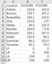
| + | *In order to show geographical visualization, we can use the X-coordinate and Y-coordinate get from the given waterway picture, use the annotate point function from Tableau to get the data of these 10 locations. | ||
| + | <p> [[Image:003.JPG|180px]] | ||
| + | *Variable Exploration | ||
| + | |||
| + | |||
|- | |- | ||
|} | |} | ||
<!-- END OF Data preparation--> | <!-- END OF Data preparation--> | ||
Revision as of 12:06, 8 July 2018
VAST Challenge 2018:Mini-Challenge 2: Like a Duck to Water
|
|
|
|
|
Tools
|
Data preparation
|

