Summary
|
|
|
|
|
|
|
Contents
The Next Steps
Is the disease contained? We are going to approach this question from 2 angles.
- How fast the disease spread?
- How many areas has the disease spread to?
Finally with a recommendation and reason for the conclusion at the end
How fast the disease spread
Back to our timeline Viz. We already know Downtown and Uptown are ground zero area. The change in the number of messages spike up overnight for these two areas. Setting the filter to only Downtown and Uptown, we can see a very steep slope that began on the 18th May, which clearly indicates the speed at which the disease spread is fast.
Refer to Image 1.
Image 1 – DownTown and Uptown
Moving on to other areas in Smartpolis, we also see a similar trend where there is a spike up in records. The difference between the area lies in the magnitude of increase from the Area’s average. Refer to Image 2.
This magnitude difference can be explained by Daytime population vs Population Density. Bringing back the chart which we have seen in earlier discussion - Image 3. In this image, the lower the number of people movement, the lesser the expected number of messages. Which can be seen as a upward sloping curve on the chart. As an example, 2 areas were selected in Image 3 namely Smogtown and Cornertown. These two areas has the lowest difference between daytime population vs population density (Population movement) which corresponds to the lowest number of records in Smartpolis.
Image 2 – All other areas
Image 3 – Population movement
How many areas has shown signs of infection?
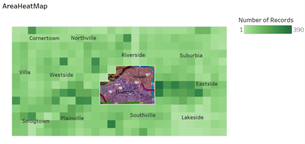
Bringing back your attention to Image 2 above. Most areas show a similar rhythm and happening on the same day, 18th. It is highly possible sign that these areas share the same type of disease as ground zero. A further test to this idea is through the AreaHeatMap, excluding Downtown and Uptown. In Image 4 below, we can see that there are only a few grids with lighter color. One such area is on the lower right. That area is Lakeside and it has a 3 lakes in that area, thus, we are not expecting people to message from these areas. We can conclude with confidence that most area in Smartpolis has already been infected.
Image 4 – AreaHeatMap
Recommendation and Conclusion
From the above, the disease spread is fast. And with people movement, the disease can spread fast, far and wide. Also, most areas in Smartpolis have already been infected.
This disease is currently NOT contained, given what we have discussed above. Plus, there are highways in/out of Smartpolis and an airport which can bring the disease to greater distance. The fortunate thing is, we know how the disease spread, which is human to human interaction. Thus, with actions taken, we should be able to prevent the disease from spreading
Given that the disease is spread through human to human interaction, it is highly recommended that health officials take the necessary steps and continue to monitor the situation. Some of the recommended steps are:
- Encourage to work from home
- Avoid crowded areas
- Events and outdoor activities to be avoided until further notice.


