Difference between revisions of "ISSS608 2017-18 T1 Assign DENG CHUNLING"
Jump to navigation
Jump to search
Cldeng.2016 (talk | contribs) |
Cldeng.2016 (talk | contribs) |
||
| Line 40: | Line 40: | ||
! Variable !! Treatment !! Tool !! Remark | ! Variable !! Treatment !! Tool !! Remark | ||
|- | |- | ||
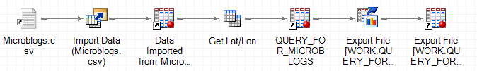
| − | | Location|| Break into "Lat" and "Lon" respectively|| SAS EG || | + | | Location|| Break into "Lat" and "Lon" respectively|| SAS EG || [[File:DCLEG1.PNG|framed|left|SAS EG workflow to prepare Lat/Lon and save to library]] |
|- | |- | ||
| Text || Find meaningful symptoms || SAS EG || According to pre-defined list of common symptoms | | Text || Find meaningful symptoms || SAS EG || According to pre-defined list of common symptoms | ||
Revision as of 18:11, 15 October 2017
 Disease Outbreak Investigation
Contents
Objective & Methodology
In light of the serious situation that Smartpolis faces (several deaths reported!), I need to:
1. Source: Determine origin of disease outbreak
2. Spread: Find out medium of transmission
3. Control: Suggest measures to contain spread
My approach to this problem is:
| Action Step | Result |
|---|---|
| Filter blog text for spots of flu | Exclude non-disease blogs from analysis |
| Determine type of symptoms | Categorise symptoms into water, air or human |
| Correlate spots with map and time | Animate disease outbreak path by timelapse |
| Drill down into water-borne | Study the origin, spread and contributing factor |
| Drill down into air-borne | Study the origin, spread and contributing factor |
| Drill down into human-transmitted | Study the origin, spread and contributing factor |
So that I can suggest containment measures and geo-fencing for each of the transmission type.
Data Preparation
Efforts are needed to transform the "Microblog" dataset into a format that is conducive for visualization.
| Variable | Treatment | Tool | Remark |
|---|---|---|---|
| Location | Break into "Lat" and "Lon" respectively | SAS EG |  SAS EG workflow to prepare Lat/Lon and save to library |
| Text | Find meaningful symptoms | SAS EG | According to pre-defined list of common symptoms |
| Adhoc | Transformation as necessary | Tableau | Visualization tricks |
SAS EG workflow to prepare Lat/Lon and save to library
Origin and Spread
Transmission and Containment
Transmission Medium - Water, Air or Human Interaction?
Containment Suggestions
Link to Tableau Page
Here