Difference between revisions of "ISSS608 2016-17 T3 Assign MANISH MITTAL DataPrep"
Jump to navigation
Jump to search
Manishm.2016 (talk | contribs) |
Manishm.2016 (talk | contribs) |
||
| Line 30: | Line 30: | ||
[[File:Missingman1.png|900px]] | [[File:Missingman1.png|900px]] | ||
| + | Convert the wind speed from m/s to MPH as it is given that the given nature park map is divided is 200 X 200 dimensions ( / 12 each) . | ||
| + | Hence convert the wind speed value using the formula: | ||
| + | Wind speed (MPH) = Wind Speed (m/s) * 2.23 | ||
| + | Wind Speed (Grids) = Wind Speed (MPH) * (200/12) | ||
| + | |||
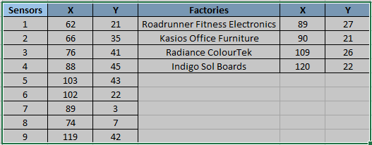
| + | Map the sensor to their location and name them X and Y. Refer to the table below for clarity. The location column is for information purpose provided by VAST and it is used to obtain X and Y values. | ||
| + | |||
| + | [[File:Coordinatesssss.png|900px]] | ||
[[File:Mmi1.png|900px]] | [[File:Mmi1.png|900px]] | ||
Revision as of 16:32, 17 July 2017
|
|
|
|
|
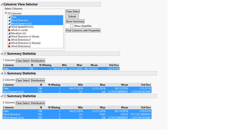
To check the missing pattern -
Convert the wind speed from m/s to MPH as it is given that the given nature park map is divided is 200 X 200 dimensions ( / 12 each) . Hence convert the wind speed value using the formula: Wind speed (MPH) = Wind Speed (m/s) * 2.23 Wind Speed (Grids) = Wind Speed (MPH) * (200/12)
Map the sensor to their location and name them X and Y. Refer to the table below for clarity. The location column is for information purpose provided by VAST and it is used to obtain X and Y values.

